Qian’an geodata
Qian’an (Jilin) is a seat of a third-order administrative division; located in China in Asia/Shanghai (GMT+8) time zone. In our database, there are 1268 cities with bigger population. Compared to other cities in China, 93.9% of cities are located further ↓South; 93.9% of cities are located further ←West and 53.1% of cities have higher elevation than Qian’an. Note1


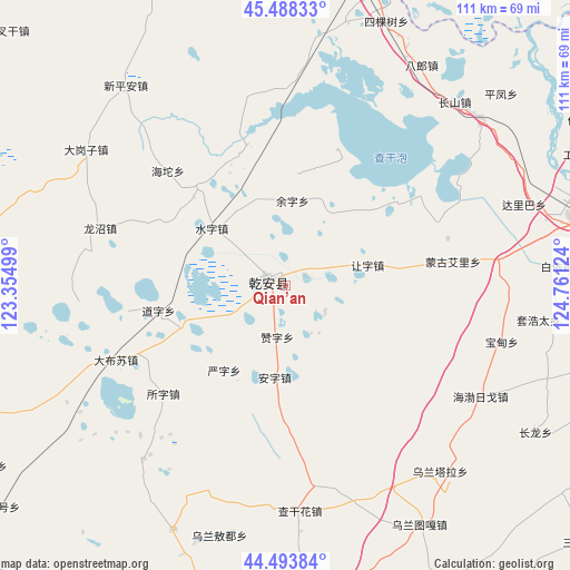
Qian’an GPS coordinates[2]
44° 59' 35.664" North, 124° 3' 29.196" East
| Map corner | latitude | longitude |
|---|---|---|
| Upper-left | 45.48833°, | 123.35499° |
| Center: | 44.99324°, | 124.05811° |
| Lower-right: | 44.49384°, | 124.76124° |
| Map W x H: | 110.6×110.6 km | = 68.7×68.7mi |
| max Lat: | 53.31946° ⇑6.1% North |
| Qian’an: | 44.99324° |
| min Lat: | ⇓93.9% South 18.22056° |
| min Long | Qian’an | max Long |
| 75.07348° | 124.05811° | 134.28917° |
| W 93.9%⇐ | ⇒6.1% E |
Elevation
Elevation of Qian’an is 143 m = 469 ft, and this is 341.8 m = 1121 ft below average elevation for this country.
| Max E: |
5622 m = 18445 ft | 53.1% |
| Avg. | 484.8 m = 1591 ft | |
| Qian’an | 143 m = 469 ft | |
Min E: |
-3 m = -10 ft | 46.9% |
See also: China elevation on elevation.city.
Geographical zone
Qian’an is located in North temperate zone (between Tropic of Cancer and the Arctic Circle). Distance of this Northern Tropic circle is 2396.9 km =1489.4 mi to South.| Distance of | km | miles | from Qian’an |
|---|---|---|---|
| North Pole | 5004.3 | 3109.5 | to North |
| Arctic Circle | 2398.4 | 1490.3 | to North |
| Tropic Cancer | 2396.9 | 1489.4 | to South |
| Equator | 5002.8 | 3108.6 | to South |


Nearby cities:
15 places around Qian’an: (largest is in red/bold)
• Baokang
114 km =70.8 mi,  211°
211°
• Changling
81.1 km =50.4 mi,  183°
183°
• Dalai
59.4 km =36.9 mi,  18°
18°
• Deshun
103.8 km =64.5 mi,  296°
296°
• Fuyu
63.2 km =39.3 mi,  70°
70°
• Guangming
106.9 km =66.4 mi,  290°
290°
• Heishui
100.1 km =62.2 mi,  283°
283°
• Kaitong
74.3 km =46.2 mi,  254°
254°
• Nong’an
111 km =69 mi,  127°
127°
• Shuanggang
90 km =55.9 mi, 277°
• Songyuan
62.3 km =38.7 mi,  75°
75°
• Xi Ail
99.5 km =61.8 mi,  264°
264°
• Xinhua
104.5 km =64.9 mi,  244°
244°
• Zhaoyuan
101.3 km =62.9 mi,  56°
56°
• Zhenlai
112.2 km =69.7 mi,  328°
328°
Sources, notices
• [Note1] Compared only with cities in China existing in our database
• [Src1] Map data: © OpenStreetMap contributors (CC-BY-SA)
• [Src2] Other city data from geonames.org with taken over terms of usage.
• [Src3] Geographical zone / Annual Mean Temperature by Robert A. Rohde @ Wikipedia
