Changling geodata
Changling (Jilin) is a seat of a third-order administrative division; located in China in Asia/Shanghai (GMT+8) time zone. With population of 55,841 people, there are 783 cities with bigger population in this country. Compared to other cities in China, 93.1% of cities are located further ↓South; 93.8% of cities are located further ←West and 53.2% of cities have lower elevation than Changling. Note1


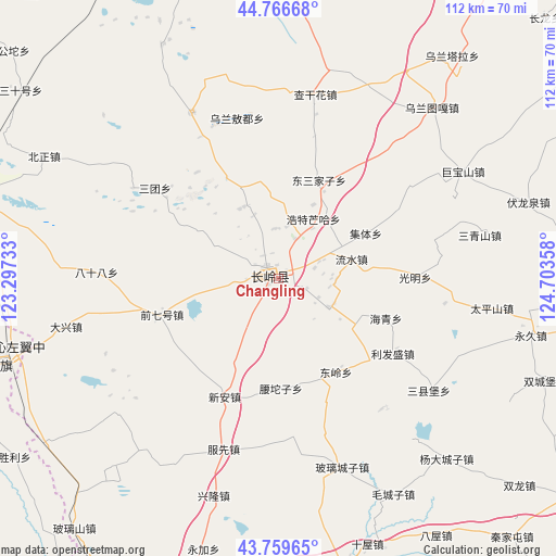
Changling GPS coordinates[2]
44° 15' 55.152" North, 124° 0' 1.62" East
| Map corner | latitude | longitude |
|---|---|---|
| Upper-left | 44.76668°, | 123.29733° |
| Center: | 44.26532°, | 124.00045° |
| Lower-right: | 43.75965°, | 124.70358° |
| Map W x H: | 112×112 km | = 69.6×69.6mi |
| max Lat: | 53.31946° ⇑6.9% North |
| Changling: | 44.26532° |
| min Lat: | ⇓93.1% South 18.22056° |
| min Long | Changling | max Long |
| 75.07348° | 124.00045° | 134.28917° |
| W 93.8%⇐ | ⇒6.2% E |
Elevation
Elevation of Changling is 190 m = 623 ft, and this is 294.8 m = 967 ft below average elevation for this country.
| Max E: |
5622 m = 18445 ft | 46.8% |
| Avg. | 484.8 m = 1591 ft | |
| Changling | 190 m = 623 ft | |
Min E: |
-3 m = -10 ft | 53.2% |
See also: Changling elevation on elevation.city.
Geographical zone
Changling is located in North temperate zone (between Tropic of Cancer and the Arctic Circle). Distance of this Northern Tropic circle is 2315.9 km =1439 mi to South.| Distance of | km | miles | from Changling |
|---|---|---|---|
| North Pole | 5085.2 | 3159.8 | to North |
| Arctic Circle | 2479.3 | 1540.6 | to North |
| Tropic Cancer | 2315.9 | 1439 | to South |
| Equator | 4921.8 | 3058.3 | to South |


Nearby cities:
15 places around Changling: (largest is in red/bold)
• Bamiancheng
118.8 km =73.8 mi,  178°
178°
• Baokang
57.8 km =35.9 mi,  253°
253°
• Changchun
114 km =70.8 mi,  112°
112°
• Fujia
110.2 km =68.5 mi,  187°
187°
• Fuyu
120.7 km =75 mi,  32°
32°
• Gongzhuling
107.4 km =66.7 mi,  142°
142°
• Kaitong
90.9 km =56.5 mi,  312°
312°
• Lishu
110 km =68.4 mi,  166°
166°
• Nong’an
93.8 km =58.3 mi,  82°
82°
• Qian’an
81.1 km =50.4 mi,  3°
3°
• Qujiadian
116.1 km =72.1 mi, 182°
• Songyuan
116.2 km =72.2 mi, 34°
• Xi Ail
118.4 km =73.6 mi, 306°
• Xinhua
96.7 km =60.1 mi,  291°
291°
• Zhengjiatun
93.2 km =57.9 mi,  205°
205°
Sources, notices
• [Note1] Compared only with cities in China existing in our database
• [Src1] Map data: © OpenStreetMap contributors (CC-BY-SA)
• [Src2] Other city data from geonames.org with taken over terms of usage.
• [Src3] Geographical zone / Annual Mean Temperature by Robert A. Rohde @ Wikipedia
