Songyuan geodata
Songyuan (Jilin) is a seat of a second-order administrative division; located in China in Asia/Shanghai (GMT+8) time zone. With population of 113,611 people, there are 383 cities with bigger population in this country. Compared to other cities in China, 94% of cities are located further ↓South; 94.6% of cities are located further ←West and 54.6% of cities have higher elevation than Songyuan. Note1


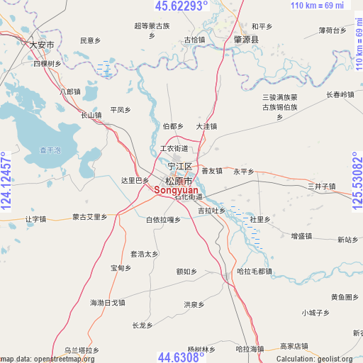
Songyuan GPS coordinates[2]
45° 7' 44.472" North, 124° 49' 39.684" East
| Map corner | latitude | longitude |
|---|---|---|
| Upper-left | 45.62293°, | 124.12457° |
| Center: | 45.12902°, | 124.82769° |
| Lower-right: | 44.6308°, | 125.53082° |
| Map W x H: | 110.3×110.3 km | = 68.5×68.5mi |
| max Lat: | 53.31946° ⇑6% North |
| Songyuan: | 45.12902° |
| min Lat: | ⇓94% South 18.22056° |
| min Long | Songyuan | max Long |
| 75.07348° | 124.82769° | 134.28917° |
| W 94.6%⇐ | ⇒5.4% E |
Elevation
Elevation of Songyuan is 134 m = 440 ft, and this is 350.8 m = 1151 ft below average elevation for this country.
| Max E: |
5622 m = 18445 ft | 54.6% |
| Avg. | 484.8 m = 1591 ft | |
| Songyuan | 134 m = 440 ft | |
Min E: |
-3 m = -10 ft | 45.4% |
See also: Songyuan elevation on elevation.city.
Geographical zone
Songyuan is located in North temperate zone (between Tropic of Cancer and the Arctic Circle). Distance of this North polar circle is 2383.3 km =1480.9 mi to North.| Distance of | km | miles | from Songyuan |
|---|---|---|---|
| North Pole | 4989.2 | 3100.1 | to North |
| Arctic Circle | 2383.3 | 1480.9 | to North |
| Tropic Cancer | 2412 | 1498.7 | to South |
| Equator | 5017.9 | 3118 | to South |


Nearby cities:
15 places around Songyuan: (largest is in red/bold)
• Bajingzi
99.6 km =61.9 mi,  355°
355°
• Changde
113.5 km =70.5 mi,  7°
7°
• Changling
116.2 km =72.2 mi,  214°
214°
• Dalai
58.3 km =36.2 mi,  314°
314°
• Datong
100.6 km =62.5 mi, 359°
• Dehui
95.5 km =59.3 mi,  133°
133°
• Fuyu
6.1 km =3.8 mi,  351°
351°
• Gaotaizi
111.5 km =69.3 mi, 358°
• Nong’an
87.3 km =54.2 mi,  162°
162°
• Qian’an
62.3 km =38.7 mi,  255°
255°
• Sanchahe
95.1 km =59.1 mi,  101°
101°
• Shuangcheng
116.6 km =72.5 mi,  77°
77°
• Shuangyushu
113.5 km =70.5 mi, 351°
• Zhaoyuan
47.7 km =29.6 mi,  30°
30°
• Zhaozhou
72.5 km =45 mi, 31°
Sources, notices
• [Note1] Compared only with cities in China existing in our database
• [Src1] Map data: © OpenStreetMap contributors (CC-BY-SA)
• [Src2] Other city data from geonames.org with taken over terms of usage.
• [Src3] Geographical zone / Annual Mean Temperature by Robert A. Rohde @ Wikipedia
