Sanchakou Chaoxianzu geodata
Sanchakou Chaoxianzu (Heilongjiang) is a seat of a fourth-order administrative division; located in China in Asia/Shanghai (GMT+8) time zone. In our database, there are 1268 cities with bigger population. Compared to other cities in China, 92.8% of cities are located further ↓South; 100% of cities are located further ←West and 60.1% of cities have higher elevation than Sanchakou Chaoxianzu. Note1


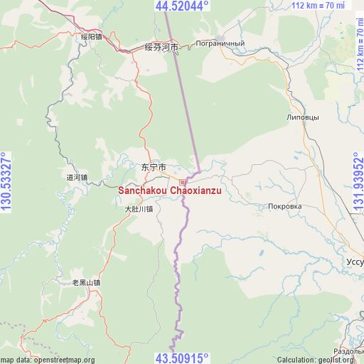
Sanchakou Chaoxianzu GPS coordinates[2]
44° 1' 1.02" North, 131° 14' 11.004" East
| Map corner | latitude | longitude |
|---|---|---|
| Upper-left | 44.52044°, | 130.53327° |
| Center: | 44.01695°, | 131.23639° |
| Lower-right: | 43.50915°, | 131.93952° |
| Map W x H: | 112.4×112.4 km | = 69.8×69.8mi |
| max Lat: | 53.31946° ⇑7.2% North |
| Sanchakou Chaoxianzu: | 44.01695° |
| min Lat: | ⇓92.8% South 18.22056° |
| min Long | Sanchakou Chaox | max Long |
| 75.07348° | 131.23639° | 134.28917° |
| W 100%⇐ | ⇒0% E |
Elevation
Elevation of Sanchakou Chaoxianzu is 98 m = 322 ft, and this is 386.8 m = 1269 ft below average elevation for this country.
| Max E: |
5622 m = 18445 ft | 60.1% |
| Avg. | 484.8 m = 1591 ft | |
| Sanchakou Chaoxianzu | 98 m = 322 ft | |
Min E: |
-3 m = -10 ft | 39.9% |
See also: China elevation on elevation.city.
Geographical zone
Sanchakou Chaoxianzu is located in North temperate zone (between Tropic of Cancer and the Arctic Circle). Distance of this Northern Tropic circle is 2288.3 km =1421.9 mi to South.| Distance of | km | miles | from Sanchakou Chaoxianzu |
|---|---|---|---|
| North Pole | 5112.8 | 3176.9 | to North |
| Arctic Circle | 2506.9 | 1557.7 | to North |
| Tropic Cancer | 2288.3 | 1421.9 | to South |
| Equator | 4894.2 | 3041.1 | to South |


Nearby cities:
15 places around Sanchakou Chaoxianzu: (largest is in red/bold)
• Daduchuan
15.7 km =9.8 mi,  239°
239°
• Daohe
32.7 km =20.3 mi,  273°
273°
• Dongning
10.5 km =6.5 mi,  298°
298°
• Fulu
114.6 km =71.2 mi,  333°
333°
• Gonghe
83.1 km =51.6 mi,  277°
277°
• Jincang
94.8 km =58.9 mi,  219°
219°
• Laoheishan
44.4 km =27.6 mi, 220°
• Luozigou
78.6 km =48.8 mi,  245°
245°
• Maqiaohe
93.4 km =58 mi,  323°
323°
• Muleng
96.3 km =59.8 mi,  305°
305°
• Suifenhe
43.2 km =26.8 mi,  350°
350°
• Suiyang
53.2 km =33.1 mi, 327°
• Xiachengzi
97.1 km =60.3 mi, 320°
• Xingyuan
96.6 km =60 mi, 311°
• Xitumenzi
92.3 km =57.4 mi,  188°
188°
Sources, notices
• [Note1] Compared only with cities in China existing in our database
• [Src1] Map data: © OpenStreetMap contributors (CC-BY-SA)
• [Src2] Other city data from geonames.org with taken over terms of usage.
• [Src3] Geographical zone / Annual Mean Temperature by Robert A. Rohde @ Wikipedia
