Dongning geodata
Dongning (Heilongjiang) is a seat of a third-order administrative division; located in China in Asia/Shanghai (GMT+8) time zone. With population of 61,440 people, there are 711 cities with bigger population in this country. Compared to other cities in China, 92.8% of cities are located further ↓South; 99.9% of cities are located further ←West and 57.5% of cities have higher elevation than Dongning. Note1


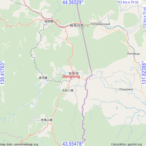
Dongning GPS coordinates[2]
44° 3' 43.884" North, 131° 7' 14.7" East
| Map corner | latitude | longitude |
|---|---|---|
| Upper-left | 44.56529°, | 130.41763° |
| Center: | 44.06219°, | 131.12075° |
| Lower-right: | 43.55478°, | 131.82388° |
| Map W x H: | 112.4×112.4 km | = 69.8×69.8mi |
| max Lat: | 53.31946° ⇑7.2% North |
| Dongning: | 44.06219° |
| min Lat: | ⇓92.8% South 18.22056° |
| min Long | Dongning | max Long |
| 75.07348° | 131.12075° | 134.28917° |
| W 99.9%⇐ | ⇒0.099999999999994% E |
Elevation
Elevation of Dongning is 114 m = 374 ft, and this is 370.8 m = 1217 ft below average elevation for this country.
| Max E: |
5622 m = 18445 ft | 57.5% |
| Avg. | 484.8 m = 1591 ft | |
| Dongning | 114 m = 374 ft | |
Min E: |
-3 m = -10 ft | 42.5% |
See also: Dongning elevation on elevation.city.
Geographical zone
Dongning is located in North temperate zone (between Tropic of Cancer and the Arctic Circle). Distance of this Northern Tropic circle is 2293.3 km =1425 mi to South.| Distance of | km | miles | from Dongning |
|---|---|---|---|
| North Pole | 5107.8 | 3173.8 | to North |
| Arctic Circle | 2501.9 | 1554.6 | to North |
| Tropic Cancer | 2293.3 | 1425 | to South |
| Equator | 4899.3 | 3044.3 | to South |


Nearby cities:
15 places around Dongning: (largest is in red/bold)
• Daduchuan
13.7 km =8.5 mi,  198°
198°
• Daohe
23.6 km =14.7 mi,  262°
262°
• Fulu
106.1 km =65.9 mi,  336°
336°
• Gonghe
73.4 km =45.6 mi,  274°
274°
• Jincang
93.3 km =58 mi,  213°
213°
• Laoheishan
43.5 km =27 mi, 206°
• Luozigou
72.7 km =45.2 mi,  239°
239°
• Maqiaohe
84 km =52.2 mi,  326°
326°
• Muleng
85.9 km =53.4 mi,  306°
306°
• Sanchakou Chaoxianzu
10.5 km =6.5 mi,  118°
118°
• Suifenhe
37.6 km =23.4 mi,  3°
3°
• Suiyang
44.3 km =27.5 mi, 334°
• Xiachengzi
87.5 km =54.4 mi,  322°
322°
• Xingyuan
86.4 km =53.7 mi, 313°
• Xitumenzi
96.5 km =60 mi,  182°
182°
Sources, notices
• [Note1] Compared only with cities in China existing in our database
• [Src1] Map data: © OpenStreetMap contributors (CC-BY-SA)
• [Src2] Other city data from geonames.org with taken over terms of usage.
• [Src3] Geographical zone / Annual Mean Temperature by Robert A. Rohde @ Wikipedia
