Daduchuan geodata
Daduchuan (Heilongjiang) is a seat of a fourth-order administrative division; located in China in Asia/Shanghai (GMT+8) time zone. In our database, there are 1268 cities with bigger population. Compared to other cities in China, 92.7% of cities are located further ↓South; 99.9% of cities are located further ←West and 50.2% of cities have higher elevation than Daduchuan. Note1


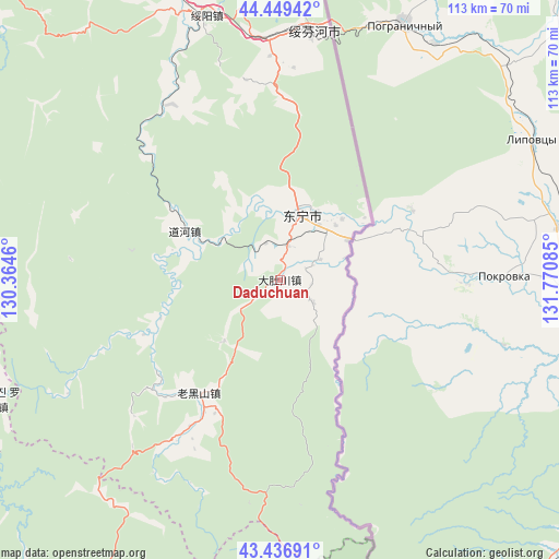
Daduchuan GPS coordinates[2]
43° 56' 43.152" North, 131° 4' 3.792" East
| Map corner | latitude | longitude |
|---|---|---|
| Upper-left | 44.44942°, | 130.3646° |
| Center: | 43.94532°, | 131.06772° |
| Lower-right: | 43.43691°, | 131.77085° |
| Map W x H: | 112.6×112.6 km | = 70×70mi |
| max Lat: | 53.31946° ⇑7.3% North |
| Daduchuan: | 43.94532° |
| min Lat: | ⇓92.7% South 18.22056° |
| min Long | Daduchuan | max Long |
| 75.07348° | 131.06772° | 134.28917° |
| W 99.9%⇐ | ⇒0.099999999999994% E |
Elevation
Elevation of Daduchuan is 163 m = 535 ft, and this is 321.8 m = 1056 ft below average elevation for this country.
| Max E: |
5622 m = 18445 ft | 50.2% |
| Avg. | 484.8 m = 1591 ft | |
| Daduchuan | 163 m = 535 ft | |
Min E: |
-3 m = -10 ft | 49.8% |
See also: China elevation on elevation.city.
Geographical zone
Daduchuan is located in North temperate zone (between Tropic of Cancer and the Arctic Circle). Distance of this Northern Tropic circle is 2280.3 km =1416.9 mi to South.| Distance of | km | miles | from Daduchuan |
|---|---|---|---|
| North Pole | 5120.8 | 3181.9 | to North |
| Arctic Circle | 2514.9 | 1562.7 | to North |
| Tropic Cancer | 2280.3 | 1416.9 | to South |
| Equator | 4886.3 | 3036.2 | to South |


Nearby cities:
15 places around Daduchuan: (largest is in red/bold)
• Daohe
21.5 km =13.4 mi,  297°
297°
• Dongning
13.7 km =8.5 mi,  18°
18°
• Gonghe
71.4 km =44.4 mi,  284°
284°
• Jiguan
110.2 km =68.5 mi,  241°
241°
• Jincang
80.2 km =49.8 mi,  216°
216°
• Laoheishan
30 km =18.6 mi,  210°
210°
• Luozigou
63.1 km =39.2 mi,  247°
247°
• Maqiaohe
93.1 km =57.8 mi,  332°
332°
• Muleng
91.2 km =56.7 mi,  314°
314°
• Sanchakou Chaoxianzu
15.7 km =9.8 mi,  59°
59°
• Suifenhe
50.9 km =31.6 mi,  7°
7°
• Suiyang
55 km =34.2 mi,  344°
344°
• Xiachengzi
95.9 km =59.6 mi, 329°
• Xingyuan
93.1 km =57.8 mi,  320°
320°
• Xitumenzi
83.4 km =51.8 mi,  179°
179°
Sources, notices
• [Note1] Compared only with cities in China existing in our database
• [Src1] Map data: © OpenStreetMap contributors (CC-BY-SA)
• [Src2] Other city data from geonames.org with taken over terms of usage.
• [Src3] Geographical zone / Annual Mean Temperature by Robert A. Rohde @ Wikipedia
