Benxi geodata
Benxi (Liaoning) is a populated place; located in China in Asia/Shanghai (GMT+8) time zone. With population of 987,717 people, there are 67 cities with bigger population in this country. Compared to other cities in China, 89.7% of cities are located further ↓South; 93.5% of cities are located further ←West and 55.6% of cities have lower elevation than Benxi. Note1


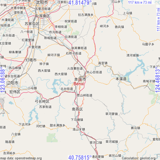
Benxi GPS coordinates[2]
41° 17' 18.996" North, 123° 45' 54" East
| Map corner | latitude | longitude |
|---|---|---|
| Upper-left | 41.81479°, | 123.06188° |
| Center: | 41.28861°, | 123.765° |
| Lower-right: | 40.75815°, | 124.46813° |
| Map W x H: | 117.5×117.5 km | = 73×73mi |
| max Lat: | 53.31946° ⇑10.3% North |
| Benxi: | 41.28861° |
| min Lat: | ⇓89.7% South 18.22056° |
| min Long | Benxi | max Long |
| 75.07348° | 123.765° | 134.28917° |
| W 93.5%⇐ | ⇒6.5% E |
Elevation
Elevation of Benxi is 212 m = 696 ft, and this is 272.8 m = 895 ft below average elevation for this country.
| Max E: |
5622 m = 18445 ft | 44.4% |
| Avg. | 484.8 m = 1591 ft | |
| Benxi | 212 m = 696 ft | |
Min E: |
-3 m = -10 ft | 55.6% |
See also: Benxi elevation on elevation.city.
Geographical zone
Benxi is located in North temperate zone (between Tropic of Cancer and the Arctic Circle). Distance of this Northern Tropic circle is 1984.9 km =1233.4 mi to South.| Distance of | km | miles | from Benxi |
|---|---|---|---|
| North Pole | 5416.2 | 3365.5 | to North |
| Arctic Circle | 2810.3 | 1746.2 | to North |
| Tropic Cancer | 1984.9 | 1233.4 | to South |
| Equator | 4590.9 | 2852.7 | to South |


Nearby cities:
15 places around Benxi: (largest is in red/bold)
• Caohekou
47 km =29.2 mi,  165°
165°
• Caohezhang
33.7 km =20.9 mi,  136°
136°
• Gongchangling
32.6 km =20.3 mi,  234°
234°
• Guanyinge
29.3 km =18.2 mi,  84°
84°
• Jiubing
48.7 km =30.3 mi,  36°
36°
• Liaoyang
49.5 km =30.8 mi,  267°
267°
• Majuanzi
56.9 km =35.4 mi,  62°
62°
• Nandianzi
50.6 km =31.4 mi,  90°
90°
• Qinghecheng
42.6 km =26.5 mi, 64°
• Shangmatun
51.1 km =31.8 mi,  221°
221°
• Sujiatun
54.4 km =33.8 mi,  319°
319°
• Tianshifu
49.3 km =30.6 mi, 94°
• Tongyuanpu
56.6 km =35.2 mi, 167°
• Xiadahe
52.2 km =32.4 mi, 231°
• Xiaoshi
29.7 km =18.5 mi, 88°
Sources, notices
• [Note1] Compared only with cities in China existing in our database
• [Src1] Map data: © OpenStreetMap contributors (CC-BY-SA)
• [Src2] Other city data from geonames.org with taken over terms of usage.
• [Src3] Geographical zone / Annual Mean Temperature by Robert A. Rohde @ Wikipedia
