Ulan geodata
Ulan (Inner Mongolia) is a seat of a third-order administrative division; located in China in Asia/Shanghai (GMT+8) time zone. In our database, there are 1268 cities with bigger population. Compared to other cities in China, 83.1% of cities are located further ↓South; 80.6% of cities are located further →East and 90.2% of cities have lower elevation than Ulan. Note1


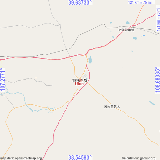
Ulan GPS coordinates[2]
39° 5' 37.464" North, 107° 58' 48.792" East
| Map corner | latitude | longitude |
|---|---|---|
| Upper-left | 39.63733°, | 107.2771° |
| Center: | 39.09374°, | 107.98022° |
| Lower-right: | 38.54593°, | 108.68335° |
| Map W x H: | 121.4×121.4 km | = 75.4×75.4mi |
| max Lat: | 53.31946° ⇑16.9% North |
| Ulan: | 39.09374° |
| min Lat: | ⇓83.1% South 18.22056° |
| min Long | Ulan | max Long |
| 75.07348° | 107.98022° | 134.28917° |
| W 19.4%⇐ | ⇒80.6% E |
Elevation
Elevation of Ulan is 1375 m = 4511 ft, and this is 890.2 m = 2921 ft above average elevation for this country.
| Max E: |
5622 m = 18445 ft | 9.8% |
| Ulan | 1375 m 4511 ft | |
| Avg. | 484.8 m = 1591 ft | |
Min E: |
-3 m = -10 ft | 90.2% |
See also: China elevation on elevation.city.
Geographical zone
Ulan is located in North temperate zone (between Tropic of Cancer and the Arctic Circle). Distance of this Northern Tropic circle is 1740.9 km =1081.7 mi to South.| Distance of | km | miles | from Ulan |
|---|---|---|---|
| North Pole | 5660.2 | 3517.1 | to North |
| Arctic Circle | 3054.4 | 1897.9 | to North |
| Tropic Cancer | 1740.9 | 1081.7 | to South |
| Equator | 4346.8 | 2701 | to South |


Nearby cities:
15 places around Ulan: (largest is in red/bold)
• Bayinsai
117.5 km =73 mi,  292°
292°
• Beijie
105.7 km =65.7 mi,  277°
277°
• Dawukou
136.9 km =85.1 mi,  267°
267°
• Galutu
93 km =57.8 mi,  126°
126°
• Huamachi
153.9 km =95.6 mi,  199°
199°
• Lasengmiao
101.9 km =63.3 mi, 284°
• Oljoq
110.7 km =68.8 mi, 203°
• Pingluo Chengguanzhen
126.1 km =78.4 mi,  260°
260°
• Qabqir
111.5 km =69.3 mi,  301°
301°
• Shitanjing
141.9 km =88.2 mi, 276°
• Shizuishan
105.5 km =65.6 mi, 278°
• Wuda
118.1 km =73.4 mi, 292°
• Wuhai
119.7 km =74.4 mi, 303°
• Xigang
153.7 km =95.5 mi,  246°
246°
• Xinli
105.6 km =65.6 mi,  37°
37°
Sources, notices
• [Note1] Compared only with cities in China existing in our database
• [Src1] Map data: © OpenStreetMap contributors (CC-BY-SA)
• [Src2] Other city data from geonames.org with taken over terms of usage.
• [Src3] Geographical zone / Annual Mean Temperature by Robert A. Rohde @ Wikipedia
