Xoixar geodata
Xoixar (Tibet) is a seat of a third-order administrative division; located in China in Asia/Shanghai (GMT+8) time zone. In our database, there are 1268 cities with bigger population. Compared to other cities in China, 74.6% of cities are located further ↑North; 96.8% of cities are located further →East and 99.5% of cities have lower elevation than Xoixar. Note1


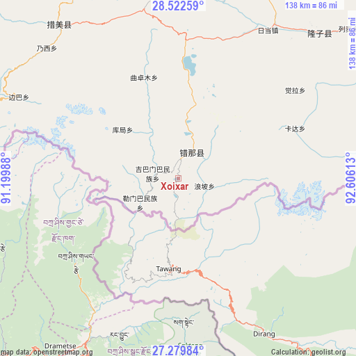
Xoixar GPS coordinates[2]
27° 54' 10.8" North, 91° 54' 10.8" East
| Map corner | latitude | longitude |
|---|---|---|
| Upper-left | 28.52259°, | 91.19988° |
| Center: | 27.903°, | 91.903° |
| Lower-right: | 27.27984°, | 92.60613° |
| Map W x H: | 138.2×138.2 km | = 85.9×85.9mi |
| max Lat: | 53.31946° ⇑74.6% North |
| Xoixar: | 27.903° |
| min Lat: | ⇓25.4% South 18.22056° |
| min Long | Xoixar | max Long |
| 75.07348° | 91.903° | 134.28917° |
| W 3.2%⇐ | ⇒96.8% E |
Elevation
Elevation of Xoixar is 4452 m = 14606 ft, and this is 3967.2 m = 13016 ft above average elevation for this country.
| Max E: |
5622 m = 18445 ft | 0.5% |
| Xoixar | 4452 m 14606 ft | |
| Avg. | 484.8 m = 1591 ft | |
Min E: |
-3 m = -10 ft | 99.5% |
See also: China elevation on elevation.city.
Geographical zone
Xoixar is located in North temperate zone (between Tropic of Cancer and the Arctic Circle). Distance of this Northern Tropic circle is 496.6 km =308.6 mi to South.| Distance of | km | miles | from Xoixar |
|---|---|---|---|
| North Pole | 6904.5 | 4290.3 | to North |
| Arctic Circle | 4298.7 | 2671.1 | to North |
| Tropic Cancer | 496.6 | 308.6 | to South |
| Equator | 3102.5 | 1927.8 | to South |


Nearby cities:
15 places around Xoixar: (largest is in red/bold)
• Bianba
69.5 km =43.2 mi,  297°
297°
• Changzhug
144 km =89.5 mi,  354°
354°
• Chaqi
157.8 km =98.1 mi,  341°
341°
• Dengmu
142.5 km =88.5 mi,  39°
39°
• Dopozhang
158.6 km =98.5 mi, 352°
• Douyu
120 km =74.6 mi,  62°
62°
• Gongbuxue
136.7 km =84.9 mi,  320°
320°
• Layu
140.4 km =87.2 mi, 350°
• Naidong
149.5 km =92.9 mi,  355°
355°
• Ngarrab
153.5 km =95.4 mi,  25°
25°
• Norbusa
149.1 km =92.6 mi,  11°
11°
• Pozhang
134.8 km =83.8 mi, 357°
• Quchomo
41.6 km =25.8 mi, 341°
• Rinang
140.9 km =87.6 mi, 29°
• Zhomda
158.3 km =98.4 mi, 34°
Sources, notices
• [Note1] Compared only with cities in China existing in our database
• [Src1] Map data: © OpenStreetMap contributors (CC-BY-SA)
• [Src2] Other city data from geonames.org with taken over terms of usage.
• [Src3] Geographical zone / Annual Mean Temperature by Robert A. Rohde @ Wikipedia
