Lhasa geodata
Lhasa (Tibet) is a seat of a first-order administrative division; located in China in Asia/Shanghai (GMT+8) time zone. With population of 118,721 people, there are 368 cities with bigger population in this country. Compared to other cities in China, 58% of cities are located further ↑North; 96.9% of cities are located further →East and 98% of cities have lower elevation than Lhasa. Note1


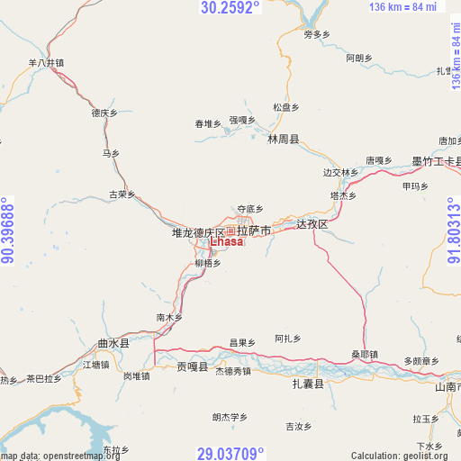
Lhasa GPS coordinates[2]
29° 39' 0" North, 91° 6' 0" East
| Map corner | latitude | longitude |
|---|---|---|
| Upper-left | 30.2592°, | 90.39688° |
| Center: | 29.65°, | 91.1° |
| Lower-right: | 29.03709°, | 91.80313° |
| Map W x H: | 135.9×135.9 km | = 84.4×84.4mi |
| max Lat: | 53.31946° ⇑58% North |
| Lhasa: | 29.65° |
| min Lat: | ⇓42% South 18.22056° |
| min Long | Lhasa | max Long |
| 75.07348° | 91.1° | 134.28917° |
| W 3.1%⇐ | ⇒96.9% E |
Elevation
Elevation of Lhasa is 3651 m = 11978 ft, and this is 3166.2 m = 10388 ft above average elevation for this country.
| Max E: |
5622 m = 18445 ft | 2% |
| Lhasa | 3651 m 11978 ft | |
| Avg. | 484.8 m = 1591 ft | |
Min E: |
-3 m = -10 ft | 98% |
See also: Lhasa elevation on elevation.city.
Geographical zone
Lhasa is located in North temperate zone (between Tropic of Cancer and the Arctic Circle). Distance of this Northern Tropic circle is 690.9 km =429.3 mi to South.| Distance of | km | miles | from Lhasa |
|---|---|---|---|
| North Pole | 6710.3 | 4169.6 | to North |
| Arctic Circle | 4104.4 | 2550.4 | to North |
| Tropic Cancer | 690.9 | 429.3 | to South |
| Equator | 3296.8 | 2048.5 | to South |


Nearby cities:
15 places around Lhasa: (largest is in red/bold)
• Caina
27.3 km =17 mi,  211°
211°
• Changzhug
82.5 km =51.3 mi,  127°
127°
• Chaqi
53.1 km =33 mi,  146°
146°
• Dagar
53.4 km =33.2 mi,  229°
229°
• Dongla
72.6 km =45.1 mi, 208°
• Dopozhang
67.7 km =42.1 mi,  123°
123°
• Dêqên
50.5 km =31.4 mi,  313°
313°
• Jibenggang
2.8 km =1.7 mi,  70°
70°
• Konggar
41.1 km =25.5 mi,  195°
195°
• Layu
77.8 km =48.3 mi,  135°
135°
• Naidong
79.3 km =49.3 mi, 124°
• Nam
26.1 km =16.2 mi,  219°
219°
• Niu
11.3 km =7 mi, 216°
• Sozhug
78.9 km =49 mi,  108°
108°
• Xumai
83.3 km =51.8 mi,  256°
256°
Sources, notices
• [Note1] Compared only with cities in China existing in our database
• [Src1] Map data: © OpenStreetMap contributors (CC-BY-SA)
• [Src2] Other city data from geonames.org with taken over terms of usage.
• [Src3] Geographical zone / Annual Mean Temperature by Robert A. Rohde @ Wikipedia
