Wulan geodata
Wulan (Gansu) is a seat of a third-order administrative division; located in China in Asia/Shanghai (GMT+8) time zone. In our database, there are 1268 cities with bigger population. Compared to other cities in China, 78.4% of cities are located further ↓South; 89.4% of cities are located further →East and 90.5% of cities have lower elevation than Wulan. Note1


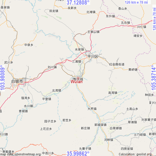
Wulan GPS coordinates[2]
36° 33' 55.476" North, 104° 41' 2.436" East
| Map corner | latitude | longitude |
|---|---|---|
| Upper-left | 37.12808°, | 103.98089° |
| Center: | 36.56541°, | 104.68401° |
| Lower-right: | 35.99862°, | 105.38714° |
| Map W x H: | 125.6×125.6 km | = 78×78mi |
| max Lat: | 53.31946° ⇑21.6% North |
| Wulan: | 36.56541° |
| min Lat: | ⇓78.4% South 18.22056° |
| min Long | Wulan | max Long |
| 75.07348° | 104.68401° | 134.28917° |
| W 10.6%⇐ | ⇒89.4% E |
Elevation
Elevation of Wulan is 1408 m = 4619 ft, and this is 923.2 m = 3029 ft above average elevation for this country.
| Max E: |
5622 m = 18445 ft | 9.5% |
| Wulan | 1408 m 4619 ft | |
| Avg. | 484.8 m = 1591 ft | |
Min E: |
-3 m = -10 ft | 90.5% |
See also: China elevation on elevation.city.
Geographical zone
Wulan is located in North temperate zone (between Tropic of Cancer and the Arctic Circle). Distance of this Northern Tropic circle is 1459.8 km =907.1 mi to South.| Distance of | km | miles | from Wulan |
|---|---|---|---|
| North Pole | 5941.4 | 3691.8 | to North |
| Arctic Circle | 3335.5 | 2072.6 | to North |
| Tropic Cancer | 1459.8 | 907.1 | to South |
| Equator | 4065.7 | 2526.3 | to South |


Nearby cities:
15 places around Wulan: (largest is in red/bold)
• Anning Xilu
100.5 km =62.4 mi,  239°
239°
• Baiyin
45.9 km =28.5 mi,  267°
267°
• Dagou
81.6 km =50.7 mi,  142°
142°
• Gangouyi
74.1 km =46 mi,  156°
156°
• Gaolan Chengguanzhen
70.9 km =44.1 mi,  248°
248°
• Hanjiaji
86.4 km =53.7 mi,  152°
152°
• Huishi
102.5 km =63.7 mi, 161°
• Lanzhou
94.4 km =58.7 mi,  233°
233°
• Renminlu
46 km =28.6 mi, 268°
• Sanhe
85.3 km =53 mi,  90°
90°
• Xihu
98.4 km =61.1 mi, 235°
• Xingpinglu
21.4 km =13.3 mi,  32°
32°
• Yitiaoshan
85.6 km =53.2 mi,  319°
319°
• Yuzhong Chengguanzhen
95.3 km =59.2 mi,  212°
212°
• Zhangyelu
95.6 km =59.4 mi, 233°
Sources, notices
• [Note1] Compared only with cities in China existing in our database
• [Src1] Map data: © OpenStreetMap contributors (CC-BY-SA)
• [Src2] Other city data from geonames.org with taken over terms of usage.
• [Src3] Geographical zone / Annual Mean Temperature by Robert A. Rohde @ Wikipedia
