Xêgar geodata
Xêgar (Tibet) is a seat of a third-order administrative division; located in China in Asia/Shanghai (GMT+8) time zone. In our database, there are 1268 cities with bigger population. Compared to other cities in China, 68.6% of cities are located further ↑North; 98.2% of cities are located further →East and 99.5% of cities have lower elevation than Xêgar. Note1


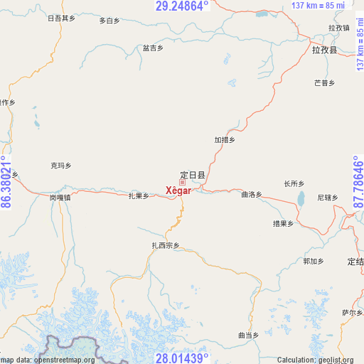
Xêgar GPS coordinates[2]
28° 37' 59.988" North, 87° 4' 59.988" East
| Map corner | latitude | longitude |
|---|---|---|
| Upper-left | 29.24864°, | 86.38021° |
| Center: | 28.63333°, | 87.08333° |
| Lower-right: | 28.01439°, | 87.78646° |
| Map W x H: | 137.2×137.2 km | = 85.3×85.3mi |
| max Lat: | 53.31946° ⇑68.6% North |
| Xêgar: | 28.63333° |
| min Lat: | ⇓31.4% South 18.22056° |
| min Long | Xêgar | max Long |
| 75.07348° | 87.08333° | 134.28917° |
| W 1.8%⇐ | ⇒98.2% E |
Elevation
Elevation of Xêgar is 4476 m = 14685 ft, and this is 3991.2 m = 13094 ft above average elevation for this country.
| Max E: |
5622 m = 18445 ft | 0.5% |
| Xêgar | 4476 m 14685 ft | |
| Avg. | 484.8 m = 1591 ft | |
Min E: |
-3 m = -10 ft | 99.5% |
See also: China elevation on elevation.city.
Geographical zone
Xêgar is located in North temperate zone (between Tropic of Cancer and the Arctic Circle). Distance of this Northern Tropic circle is 577.8 km =359 mi to South.| Distance of | km | miles | from Xêgar |
|---|---|---|---|
| North Pole | 6823.3 | 4239.8 | to North |
| Arctic Circle | 4217.4 | 2620.6 | to North |
| Tropic Cancer | 577.8 | 359 | to South |
| Equator | 3183.7 | 1978.3 | to South |


Nearby cities:
15 places around Xêgar: (largest is in red/bold)
• Camgyai
104.1 km =64.7 mi,  227°
227°
• Chongdui
121.7 km =75.6 mi,  243°
243°
• Dongxi
198.7 km =123.5 mi,  89°
89°
• Gangba
143.7 km =89.3 mi,  108°
108°
• Gyangkar
74.7 km =46.4 mi, 110°
• Jiding
139.7 km =86.8 mi,  54°
54°
• Kambaxoi
146.5 km =91 mi,  104°
104°
• Ngamring
67.2 km =41.8 mi,  6°
6°
• Quxar
75.7 km =47 mi, 46°
• Rikaze
188.1 km =116.9 mi,  68°
68°
• Saga
196.3 km =122 mi,  293°
293°
• Sajia
99.3 km =61.7 mi, 71°
• Zham
129.7 km =80.6 mi, 236°
• Zongga
183.2 km =113.8 mi,  282°
282°
• Zuobude
103.7 km =64.4 mi, 227°
Sources, notices
• [Note1] Compared only with cities in China existing in our database
• [Src1] Map data: © OpenStreetMap contributors (CC-BY-SA)
• [Src2] Other city data from geonames.org with taken over terms of usage.
• [Src3] Geographical zone / Annual Mean Temperature by Robert A. Rohde @ Wikipedia
