Saga geodata
Saga (Tibet) is a populated place; located in China in Asia/Shanghai (GMT+8) time zone. With population of 3,765 people, there are 906 cities with bigger population in this country. Compared to other cities in China, 61.7% of cities are located further ↑North; 98.6% of cities are located further →East and 99.5% of cities have lower elevation than Saga. Note1


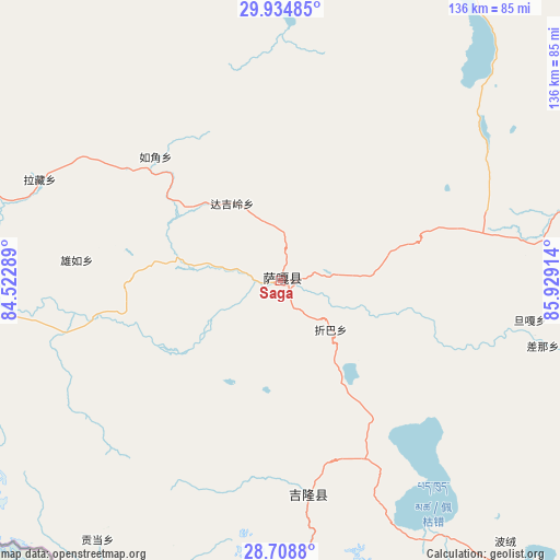
Saga GPS coordinates[2]
29° 19' 25.212" North, 85° 13' 33.636" East
| Map corner | latitude | longitude |
|---|---|---|
| Upper-left | 29.93485°, | 84.52289° |
| Center: | 29.32367°, | 85.22601° |
| Lower-right: | 28.7088°, | 85.92914° |
| Map W x H: | 136.3×136.3 km | = 84.7×84.7mi |
| max Lat: | 53.31946° ⇑61.7% North |
| Saga: | 29.32367° |
| min Lat: | ⇓38.3% South 18.22056° |
| min Long | Saga | max Long |
| 75.07348° | 85.22601° | 134.28917° |
| W 1.4%⇐ | ⇒98.6% E |
Elevation
Elevation of Saga is 4475 m = 14682 ft, and this is 3990.2 m = 13091 ft above average elevation for this country.
| Max E: |
5622 m = 18445 ft | 0.5% |
| Saga | 4475 m 14682 ft | |
| Avg. | 484.8 m = 1591 ft | |
Min E: |
-3 m = -10 ft | 99.5% |
See also: China elevation on elevation.city.
Geographical zone
Saga is located in North temperate zone (between Tropic of Cancer and the Arctic Circle). Distance of this Northern Tropic circle is 654.6 km =406.7 mi to South.| Distance of | km | miles | from Saga |
|---|---|---|---|
| North Pole | 6746.6 | 4192.1 | to North |
| Arctic Circle | 4140.7 | 2572.9 | to North |
| Tropic Cancer | 654.6 | 406.7 | to South |
| Equator | 3260.5 | 2026 | to South |


Nearby cities:
15 places around Saga: (largest is in red/bold)
• Camgyai
180.7 km =112.3 mi,  144°
144°
• Chongdui
149.1 km =92.6 mi,  151°
151°
• Gangba
339.7 km =211.1 mi,  111°
111°
• Gyangkar
270.9 km =168.3 mi, 112°
• Jiding
293.1 km =182.1 mi,  89°
89°
• Luring
341.6 km =212.3 mi,  343°
343°
• Maindong
224.2 km =139.3 mi,  4°
4°
• Ngamring
188.5 km =117.1 mi, 93°
• Quxar
236.6 km =147 mi,  96°
96°
• Sajia
278 km =172.7 mi, 99°
• Xêgar
196.3 km =122 mi, 113°
• Zhadong
108.8 km =67.6 mi,  289°
289°
• Zham
166.3 km =103.3 mi, 153°
• Zongga
36.1 km =22.4 mi,  176°
176°
• Zuobude
180.6 km =112.2 mi, 144°
Sources, notices
• [Note1] Compared only with cities in China existing in our database
• [Src1] Map data: © OpenStreetMap contributors (CC-BY-SA)
• [Src2] Other city data from geonames.org with taken over terms of usage.
• [Src3] Geographical zone / Annual Mean Temperature by Robert A. Rohde @ Wikipedia
