Xarag geodata
Xarag (Qinghai) is a seat of a fourth-order administrative division; located in China in Asia/Shanghai (GMT+8) time zone. In our database, there are 1268 cities with bigger population. Compared to other cities in China, 78% of cities are located further ↓South; 95.4% of cities are located further →East and 97.2% of cities have lower elevation than Xarag. Note1


Xarag GPS coordinates[2]
36° 24' 0" North, 98° 10' 59.988" East
| Map corner | latitude | longitude |
|---|---|---|
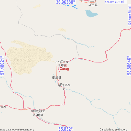
| Upper-left | 36.96388°, | 97.48021° |
| Center: | 36.4°, | 98.18333° |
| Lower-right: | 35.832°, | 98.88646° |
| Map W x H: | 125.9×125.9 km | = 78.2×78.2mi |
| max Lat: | 53.31946° ⇑22% North |
| Xarag: | 36.4° |
| min Lat: | ⇓78% South 18.22056° |
| min Long | Xarag | max Long |
| 75.07348° | 98.18333° | 134.28917° |
| W 4.6%⇐ | ⇒95.4% E |
Elevation
Elevation of Xarag is 3217 m = 10554 ft, and this is 2732.2 m = 8964 ft above average elevation for this country.
| Max E: |
5622 m = 18445 ft | 2.8% |
| Xarag | 3217 m 10554 ft | |
| Avg. | 484.8 m = 1591 ft | |
Min E: |
-3 m = -10 ft | 97.2% |
See also: China elevation on elevation.city.
Geographical zone
Xarag is located in North temperate zone (between Tropic of Cancer and the Arctic Circle). Distance of this Northern Tropic circle is 1441.4 km =895.6 mi to South.| Distance of | km | miles | from Xarag |
|---|---|---|---|
| North Pole | 5959.8 | 3703.2 | to North |
| Arctic Circle | 3353.9 | 2084 | to North |
| Tropic Cancer | 1441.4 | 895.6 | to South |
| Equator | 4047.3 | 2514.9 | to South |


Nearby cities:
15 places around Xarag: (largest is in red/bold)
• Barun
86.5 km =53.7 mi,  232°
232°
• Chaka
90.7 km =56.4 mi,  61°
61°
• Delingha
130.2 km =80.9 mi,  326°
326°
• Karmar
121.8 km =75.7 mi,  28°
28°
• Kugri
84.8 km =52.7 mi,  166°
166°
• Qagan Us
15.3 km =9.5 mi,  268°
268°
• Reshui
20 km =12.4 mi,  183°
183°
• Serh
63.4 km =39.4 mi,  15°
15°
• Tongpu
70.7 km =43.9 mi, 23°
• Xiangjia
56.1 km =34.9 mi,  203°
203°
• Xiangride
52.5 km =32.6 mi,  210°
210°
• Xinyuan
123.7 km =76.9 mi,  35°
35°
• Xireg
62.2 km =38.6 mi, 22°
• Xuji
110 km =68.4 mi,  343°
343°
• Zongjia
111.8 km =69.5 mi,  261°
261°
Sources, notices
• [Note1] Compared only with cities in China existing in our database
• [Src1] Map data: © OpenStreetMap contributors (CC-BY-SA)
• [Src2] Other city data from geonames.org with taken over terms of usage.
• [Src3] Geographical zone / Annual Mean Temperature by Robert A. Rohde @ Wikipedia
