Kugri geodata
Kugri (Qinghai) is a seat of a fourth-order administrative division; located in China in Asia/Shanghai (GMT+8) time zone. In our database, there are 1268 cities with bigger population. Compared to other cities in China, 76.4% of cities are located further ↓South; 95.3% of cities are located further →East and 98.1% of cities have lower elevation than Kugri. Note1


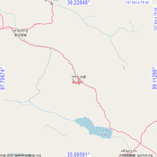
Kugri GPS coordinates[2]
35° 39' 33.264" North, 98° 24' 35.496" East
| Map corner | latitude | longitude |
|---|---|---|
| Upper-left | 36.22848°, | 97.70674° |
| Center: | 35.65924°, | 98.40986° |
| Lower-right: | 35.08591°, | 99.11299° |
| Map W x H: | 127×127 km | = 78.9×78.9mi |
| max Lat: | 53.31946° ⇑23.6% North |
| Kugri: | 35.65924° |
| min Lat: | ⇓76.4% South 18.22056° |
| min Long | Kugri | max Long |
| 75.07348° | 98.40986° | 134.28917° |
| W 4.7%⇐ | ⇒95.3% E |
Elevation
Elevation of Kugri is 3706 m = 12159 ft, and this is 3221.2 m = 10568 ft above average elevation for this country.
| Max E: |
5622 m = 18445 ft | 1.9% |
| Kugri | 3706 m 12159 ft | |
| Avg. | 484.8 m = 1591 ft | |
Min E: |
-3 m = -10 ft | 98.1% |
See also: China elevation on elevation.city.
Geographical zone
Kugri is located in North temperate zone (between Tropic of Cancer and the Arctic Circle). Distance of this Northern Tropic circle is 1359 km =844.4 mi to South.| Distance of | km | miles | from Kugri |
|---|---|---|---|
| North Pole | 6042.1 | 3754.4 | to North |
| Arctic Circle | 3436.2 | 2135.2 | to North |
| Tropic Cancer | 1359 | 844.4 | to South |
| Equator | 3964.9 | 2463.7 | to South |


Nearby cities:
15 places around Kugri: (largest is in red/bold)
• Barun
94.5 km =58.7 mi,  288°
288°
• Chaka
139.3 km =86.6 mi,  25°
25°
• Dongke
135.7 km =84.3 mi,  56°
56°
• Heihe
99.2 km =61.6 mi,  194°
194°
• Huanghe
121.8 km =75.7 mi,  183°
183°
• Huashixia
69.9 km =43.4 mi,  149°
149°
• Machali
82.3 km =51.1 mi, 191°
• Qagan Us
89.5 km =55.6 mi,  336°
336°
• Reshui
66.1 km =41.1 mi, 340°
• Wenquan
123.7 km =76.9 mi,  113°
113°
• Xarag
84.8 km =52.7 mi,  346°
346°
• Xia Dawo
106.1 km =65.9 mi,  133°
133°
• Xiangjia
53.3 km =33.1 mi,  305°
305°
• Xiangride
60.1 km =37.3 mi, 308°
• Zhalinghu
78.4 km =48.7 mi,  215°
215°
Sources, notices
• [Note1] Compared only with cities in China existing in our database
• [Src1] Map data: © OpenStreetMap contributors (CC-BY-SA)
• [Src2] Other city data from geonames.org with taken over terms of usage.
• [Src3] Geographical zone / Annual Mean Temperature by Robert A. Rohde @ Wikipedia
