Chaka geodata
Chaka (Qinghai) is a seat of a fourth-order administrative division; located in China in Asia/Shanghai (GMT+8) time zone. In our database, there are 1268 cities with bigger population. Compared to other cities in China, 78.7% of cities are located further ↓South; 95.1% of cities are located further →East and 97.1% of cities have lower elevation than Chaka. Note1


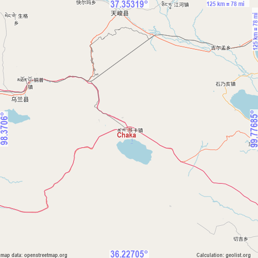
Chaka GPS coordinates[2]
36° 47' 31.884" North, 99° 4' 25.392" East
| Map corner | latitude | longitude |
|---|---|---|
| Upper-left | 37.35319°, | 98.3706° |
| Center: | 36.79219°, | 99.07372° |
| Lower-right: | 36.22705°, | 99.77685° |
| Map W x H: | 125.2×125.2 km | = 77.8×77.8mi |
| max Lat: | 53.31946° ⇑21.3% North |
| Chaka: | 36.79219° |
| min Lat: | ⇓78.7% South 18.22056° |
| min Long | Chaka | max Long |
| 75.07348° | 99.07372° | 134.28917° |
| W 4.9%⇐ | ⇒95.1% E |
Elevation
Elevation of Chaka is 3101 m = 10174 ft, and this is 2616.2 m = 8583 ft above average elevation for this country.
| Max E: |
5622 m = 18445 ft | 2.9% |
| Chaka | 3101 m 10174 ft | |
| Avg. | 484.8 m = 1591 ft | |
Min E: |
-3 m = -10 ft | 97.1% |
See also: China elevation on elevation.city.
Geographical zone
Chaka is located in North temperate zone (between Tropic of Cancer and the Arctic Circle). Distance of this Northern Tropic circle is 1485 km =922.7 mi to South.| Distance of | km | miles | from Chaka |
|---|---|---|---|
| North Pole | 5916.2 | 3676.2 | to North |
| Arctic Circle | 3310.3 | 2056.9 | to North |
| Tropic Cancer | 1485 | 922.7 | to South |
| Equator | 4090.9 | 2542 | to South |


Nearby cities:
15 places around Chaka: (largest is in red/bold)
• Dongke
73.4 km =45.6 mi,  133°
133°
• Heimahe
63 km =39.1 mi,  96°
96°
• Jirmeng
59.5 km =37 mi,  47°
47°
• Karmar
66.8 km =41.5 mi,  341°
341°
• Qagan Us
104.4 km =64.9 mi,  245°
245°
• Qiecha
51.8 km =32.2 mi,  64°
64°
• Reshui
102.9 km =63.9 mi,  231°
231°
• Serh
64.6 km =40.1 mi,  285°
285°
• Shinaihai
53.7 km =33.4 mi,  66°
66°
• Tongpu
55.3 km =34.4 mi, 292°
• Xarag
90.7 km =56.4 mi,  241°
241°
• Xinyuan
56.8 km =35.3 mi,  353°
353°
• Xireg
57.7 km =35.9 mi,  284°
284°
• Yangkang
103.1 km =64.1 mi, 343°
• Zhugkyung
94.5 km =58.7 mi,  18°
18°
Sources, notices
• [Note1] Compared only with cities in China existing in our database
• [Src1] Map data: © OpenStreetMap contributors (CC-BY-SA)
• [Src2] Other city data from geonames.org with taken over terms of usage.
• [Src3] Geographical zone / Annual Mean Temperature by Robert A. Rohde @ Wikipedia
