Serh geodata
Serh (Qinghai) is a seat of a fourth-order administrative division; located in China in Asia/Shanghai (GMT+8) time zone. In our database, there are 1268 cities with bigger population. Compared to other cities in China, 79.1% of cities are located further ↓South; 95.3% of cities are located further →East and 96.9% of cities have lower elevation than Serh. Note1


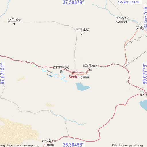
Serh GPS coordinates[2]
36° 56' 56.22" North, 98° 22' 28.668" East
| Map corner | latitude | longitude |
|---|---|---|
| Upper-left | 37.50879°, | 97.67151° |
| Center: | 36.94895°, | 98.37463° |
| Lower-right: | 36.38496°, | 99.07776° |
| Map W x H: | 125×125 km | = 77.7×77.7mi |
| max Lat: | 53.31946° ⇑20.9% North |
| Serh: | 36.94895° |
| min Lat: | ⇓79.1% South 18.22056° |
| min Long | Serh | max Long |
| 75.07348° | 98.37463° | 134.28917° |
| W 4.7%⇐ | ⇒95.3% E |
Elevation
Elevation of Serh is 2986 m = 9797 ft, and this is 2501.2 m = 8206 ft above average elevation for this country.
| Max E: |
5622 m = 18445 ft | 3.1% |
| Serh | 2986 m 9797 ft | |
| Avg. | 484.8 m = 1591 ft | |
Min E: |
-3 m = -10 ft | 96.9% |
See also: China elevation on elevation.city.
Geographical zone
Serh is located in North temperate zone (between Tropic of Cancer and the Arctic Circle). Distance of this Northern Tropic circle is 1502.4 km =933.5 mi to South.| Distance of | km | miles | from Serh |
|---|---|---|---|
| North Pole | 5898.7 | 3665.3 | to North |
| Arctic Circle | 3292.8 | 2046.1 | to North |
| Tropic Cancer | 1502.4 | 933.5 | to South |
| Equator | 4108.3 | 2552.8 | to South |


Nearby cities:
15 places around Serh: (largest is in red/bold)
• Chaka
64.6 km =40.1 mi,  105°
105°
• Delingha
100.5 km =62.4 mi,  298°
298°
• Jirmeng
108.4 km =67.4 mi,  77°
77°
• Karmar
61.5 km =38.2 mi,  41°
41°
• Qagan Us
69.3 km =43.1 mi,  207°
207°
• Qiecha
108.8 km =67.6 mi,  87°
87°
• Reshui
83.1 km =51.6 mi,  192°
192°
• Shinaihai
111.5 km =69.3 mi, 88°
• Tongpu
11.8 km =7.3 mi,  71°
71°
• Xarag
63.4 km =39.4 mi,  195°
195°
• Xinyuan
67.8 km =42.1 mi,  54°
54°
• Xireg
7.1 km =4.4 mi,  118°
118°
• Xuji
65.5 km =40.7 mi,  312°
312°
• Yangkang
88.1 km =54.7 mi,  22°
22°
• Zongwulong
102.9 km =63.9 mi, 298°
Sources, notices
• [Note1] Compared only with cities in China existing in our database
• [Src1] Map data: © OpenStreetMap contributors (CC-BY-SA)
• [Src2] Other city data from geonames.org with taken over terms of usage.
• [Src3] Geographical zone / Annual Mean Temperature by Robert A. Rohde @ Wikipedia
