Luzhang geodata
Luzhang (Yunnan) is a seat of a third-order administrative division; located in China in Asia/Shanghai (GMT+8) time zone. In our database, there are 1268 cities with bigger population. Compared to other cities in China, 82.5% of cities are located further ↑North; 95.2% of cities are located further →East and 93.5% of cities have lower elevation than Luzhang. Note1


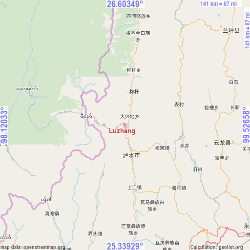
Luzhang GPS coordinates[2]
25° 58' 23.124" North, 98° 49' 24.42" East
| Map corner | latitude | longitude |
|---|---|---|
| Upper-left | 26.60349°, | 98.12033° |
| Center: | 25.97309°, | 98.82345° |
| Lower-right: | 25.33929°, | 99.52658° |
| Map W x H: | 140.6×140.6 km | = 87.4×87.4mi |
| max Lat: | 53.31946° ⇑82.5% North |
| Luzhang: | 25.97309° |
| min Lat: | ⇓17.5% South 18.22056° |
| min Long | Luzhang | max Long |
| 75.07348° | 98.82345° | 134.28917° |
| W 4.8%⇐ | ⇒95.2% E |
Elevation
Elevation of Luzhang is 1795 m = 5889 ft, and this is 1310.2 m = 4299 ft above average elevation for this country.
| Max E: |
5622 m = 18445 ft | 6.5% |
| Luzhang | 1795 m 5889 ft | |
| Avg. | 484.8 m = 1591 ft | |
Min E: |
-3 m = -10 ft | 93.5% |
See also: China elevation on elevation.city.
Geographical zone
Luzhang is located in North temperate zone (between Tropic of Cancer and the Arctic Circle). Distance of this Northern Tropic circle is 282 km =175.2 mi to South.| Distance of | km | miles | from Luzhang |
|---|---|---|---|
| North Pole | 7119.1 | 4423.6 | to North |
| Arctic Circle | 4513.2 | 2804.4 | to North |
| Tropic Cancer | 282 | 175.2 | to South |
| Equator | 2887.9 | 1794.5 | to South |


Nearby cities:
15 places around Luzhang: (largest is in red/bold)
• Baohe
144.8 km =90 mi,  20°
20°
• Dali
145.6 km =90.5 mi,  107°
107°
• Dianyang
145.2 km =90.2 mi,  166°
166°
• Jinding
80.5 km =50 mi,  49°
49°
• Jinhua
125.9 km =78.2 mi,  60°
60°
• Laojie
93.8 km =58.3 mi,  128°
128°
• Longshan
153 km =95.1 mi,  184°
184°
• Shangjie
120.6 km =74.9 mi, 106°
• Shangpa
106 km =65.9 mi,  6°
6°
• Shimen
61.2 km =38 mi,  98°
98°
• Tengyue
113.1 km =70.3 mi,  195°
195°
• Youdian
148.8 km =92.5 mi,  148°
148°
• Yuhu
116.8 km =72.6 mi,  82°
82°
• Yunhe
150.2 km =93.3 mi,  65°
65°
• Zhedao
139.6 km =86.7 mi, 203°
Sources, notices
• [Note1] Compared only with cities in China existing in our database
• [Src1] Map data: © OpenStreetMap contributors (CC-BY-SA)
• [Src2] Other city data from geonames.org with taken over terms of usage.
• [Src3] Geographical zone / Annual Mean Temperature by Robert A. Rohde @ Wikipedia
