Shinaihai geodata
Shinaihai (Qinghai) is a seat of a fourth-order administrative division; located in China in Asia/Shanghai (GMT+8) time zone. In our database, there are 1268 cities with bigger population. Compared to other cities in China, 79.1% of cities are located further ↓South; 94.8% of cities are located further →East and 97.2% of cities have lower elevation than Shinaihai. Note1


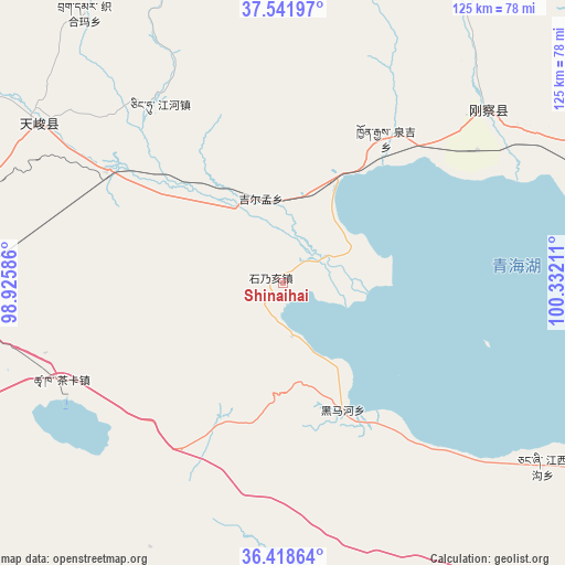
Shinaihai GPS coordinates[2]
36° 58' 56.568" North, 99° 37' 44.328" East
| Map corner | latitude | longitude |
|---|---|---|
| Upper-left | 37.54197°, | 98.92586° |
| Center: | 36.98238°, | 99.62898° |
| Lower-right: | 36.41864°, | 100.33211° |
| Map W x H: | 124.9×124.9 km | = 77.6×77.6mi |
| max Lat: | 53.31946° ⇑20.9% North |
| Shinaihai: | 36.98238° |
| min Lat: | ⇓79.1% South 18.22056° |
| min Long | Shinaihai | max Long |
| 75.07348° | 99.62898° | 134.28917° |
| W 5.2%⇐ | ⇒94.8% E |
Elevation
Elevation of Shinaihai is 3203 m = 10509 ft, and this is 2718.2 m = 8918 ft above average elevation for this country.
| Max E: |
5622 m = 18445 ft | 2.8% |
| Shinaihai | 3203 m 10509 ft | |
| Avg. | 484.8 m = 1591 ft | |
Min E: |
-3 m = -10 ft | 97.2% |
See also: China elevation on elevation.city.
Geographical zone
Shinaihai is located in North temperate zone (between Tropic of Cancer and the Arctic Circle). Distance of this Northern Tropic circle is 1506.1 km =935.8 mi to South.| Distance of | km | miles | from Shinaihai |
|---|---|---|---|
| North Pole | 5895 | 3663 | to North |
| Arctic Circle | 3289.1 | 2043.8 | to North |
| Tropic Cancer | 1506.1 | 935.8 | to South |
| Equator | 4112.1 | 2555.1 | to South |


Nearby cities:
15 places around Shinaihai: (largest is in red/bold)
• Chaka
53.7 km =33.4 mi,  246°
246°
• Dongke
72.1 km =44.8 mi,  177°
177°
• Gandi
92 km =57.2 mi,  134°
134°
• Hairag
74.8 km =46.5 mi,  69°
69°
• Heimahe
31.1 km =19.3 mi,  154°
154°
• Jiangxigou
68.8 km =42.8 mi,  124°
124°
• Jirmeng
19.6 km =12.2 mi,  344°
344°
• Karmar
82 km =51 mi,  301°
301°
• Qiecha
3 km =1.9 mi, 297°
• Sazhubxi
97.2 km =60.4 mi,  143°
143°
• Shaliuhe
58.9 km =36.6 mi,  49°
49°
• Tuohua
94.3 km =58.6 mi,  83°
83°
• Xinyuan
66 km =41 mi, 302°
• Yingde’er
81.2 km =50.5 mi, 142°
• Zhugkyung
71 km =44.1 mi, 344°
Sources, notices
• [Note1] Compared only with cities in China existing in our database
• [Src1] Map data: © OpenStreetMap contributors (CC-BY-SA)
• [Src2] Other city data from geonames.org with taken over terms of usage.
• [Src3] Geographical zone / Annual Mean Temperature by Robert A. Rohde @ Wikipedia
