Yangkang geodata
Yangkang (Qinghai) is a seat of a fourth-order administrative division; located in China in Asia/Shanghai (GMT+8) time zone. In our database, there are 1268 cities with bigger population. Compared to other cities in China, 80.6% of cities are located further ↓South; 95.2% of cities are located further →East and 99.1% of cities have lower elevation than Yangkang. Note1


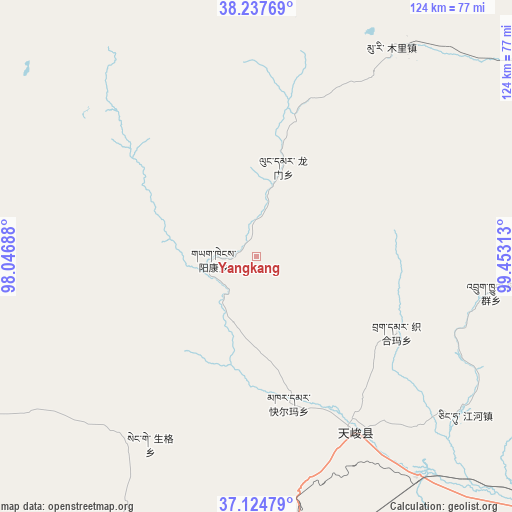
Yangkang GPS coordinates[2]
37° 40' 59.988" North, 98° 45' 0" East
| Map corner | latitude | longitude |
|---|---|---|
| Upper-left | 38.23769°, | 98.04688° |
| Center: | 37.68333°, | 98.75° |
| Lower-right: | 37.12479°, | 99.45313° |
| Map W x H: | 123.7×123.7 km | = 76.9×76.9mi |
| max Lat: | 53.31946° ⇑19.4% North |
| Yangkang: | 37.68333° |
| min Lat: | ⇓80.6% South 18.22056° |
| min Long | Yangkang | max Long |
| 75.07348° | 98.75° | 134.28917° |
| W 4.8%⇐ | ⇒95.2% E |
Elevation
Elevation of Yangkang is 4212 m = 13819 ft, and this is 3727.2 m = 12228 ft above average elevation for this country.
| Max E: |
5622 m = 18445 ft | 0.90000000000001% |
| Yangkang | 4212 m 13819 ft | |
| Avg. | 484.8 m = 1591 ft | |
Min E: |
-3 m = -10 ft | 99.1% |
See also: China elevation on elevation.city.
Geographical zone
Yangkang is located in North temperate zone (between Tropic of Cancer and the Arctic Circle). Distance of this Northern Tropic circle is 1584.1 km =984.3 mi to South.| Distance of | km | miles | from Yangkang |
|---|---|---|---|
| North Pole | 5817.1 | 3614.6 | to North |
| Arctic Circle | 3211.2 | 1995.3 | to North |
| Tropic Cancer | 1584.1 | 984.3 | to South |
| Equator | 4190 | 2603.5 | to South |


Nearby cities:
15 places around Yangkang: (largest is in red/bold)
• Chaka
103.1 km =64.1 mi,  163°
163°
• Jirmeng
93.4 km =58 mi,  129°
129°
• Karmar
36.5 km =22.7 mi,  167°
167°
• Kekeli
92.1 km =57.2 mi,  32°
32°
• Longmen
26.4 km =16.4 mi,  35°
35°
• Muri
57.2 km =35.5 mi, 29°
• Qiecha
107.2 km =66.6 mi,  135°
135°
• Serh
88.1 km =54.7 mi,  202°
202°
• Shinaihai
110.1 km =68.4 mi, 135°
• Tongpu
80.9 km =50.3 mi, 195°
• Xinyuan
48 km =29.8 mi,  152°
152°
• Xireg
89.2 km =55.4 mi, 197°
• Xuji
89 km =55.3 mi,  245°
245°
• Yeniugou
106.6 km =66.2 mi, 39°
• Zhugkyung
59.2 km =36.8 mi,  99°
99°
Sources, notices
• [Note1] Compared only with cities in China existing in our database
• [Src1] Map data: © OpenStreetMap contributors (CC-BY-SA)
• [Src2] Other city data from geonames.org with taken over terms of usage.
• [Src3] Geographical zone / Annual Mean Temperature by Robert A. Rohde @ Wikipedia
