Yolombó geodata
Yolombó (Antioquia) is a seat of a second-order administrative division; located in Colombia in America/Bogota (GMT-5) time zone. With population of 6,033 people, there are 449 cities with bigger population in this country. Compared to other cities in Colombia, 69.9% of cities are located further ↓South; 54.3% of cities are located further →East and 59.9% of cities have lower elevation than Yolombó. Note1


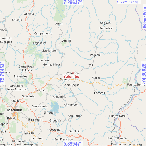
Yolombó GPS coordinates[2]
6° 35' 54.276" North, 75° 0' 41.04" West
| Map corner | latitude | longitude |
|---|---|---|
| Upper-left | 7.29637°, | -75.71453° |
| Center: | 6.59841°, | -75.0114° |
| Lower-right: | 5.89947°, | -74.30828° |
| Map W x H: | 155.3×155.3 km | = 96.5×96.5mi |
| max Lat: | 13.38166° ⇑30.1% North |
| Yolombó: | 6.59841° |
| min Lat: | ⇓69.9% South -4.21528° |
| min Long | Yolombó | max Long |
| -81.70636° | -75.0114° | -67.06996° |
| W 45.7%⇐ | ⇒54.3% E |
Elevation
Elevation of Yolombó is 1459 m = 4787 ft, and this is 309.7 m = 1016 ft above average elevation for this country.
| Max E: |
3342 m = 10965 ft | 40.1% |
| Yolombó | 1459 m 4787 ft | |
| Avg. | 1149.3 m = 3771 ft | |
Min E: |
1 m = 3 ft | 59.9% |
See also: Colombia elevation on elevation.city.
Geographical zone
Yolombó is located in North Torrid zone (between Equator and Tropic of Cancer). Distance of Equator is 733.7 km =455.9 mi to South.| Distance of | km | miles | from Yolombó |
|---|---|---|---|
| North Pole | 9273.4 | 5762.2 | to North |
| Arctic Circle | 6667.5 | 4143 | to North |
| Tropic Cancer | 1872.2 | 1163.3 | to North |
| Equator | 733.7 | 455.9 | to South |


Nearby cities:
15 places around Yolombó: (largest is in red/bold)
• Alejandría
28.4 km =17.6 mi,  210°
210°
• Amalfi
35.4 km =22 mi,  348°
348°
• Barbosa
39.6 km =24.6 mi,  243°
243°
• Caracolí
35.1 km =21.8 mi,  126°
126°
• Carolina
33 km =20.5 mi,  295°
295°
• Cisneros
10.8 km =6.7 mi,  231°
231°
• Concepción
35.5 km =22.1 mi, 230°
• Guadalupe
34.9 km =21.7 mi,  313°
313°
• Gómez Plata
24.7 km =15.3 mi,  292°
292°
• Maceo
25.3 km =15.7 mi,  101°
101°
• San Rafael
33.8 km =21 mi,  182°
182°
• San Roque
12.6 km =7.8 mi, 184°
• Santo Domingo
22 km =13.7 mi, 230°
• Vegachí
30 km =18.6 mi,  52°
52°
• Yalí
21.3 km =13.2 mi,  66°
66°
Sources, notices
• [Note1] Compared only with cities in Colombia existing in our database
• [Src1] Map data: © OpenStreetMap contributors (CC-BY-SA)
• [Src2] Other city data from geonames.org with taken over terms of usage.
• [Src3] Geographical zone / Annual Mean Temperature by Robert A. Rohde @ Wikipedia
