Yalí geodata
Yalí (Antioquia) is a seat of a second-order administrative division; located in Colombia in America/Bogota (GMT-5) time zone. With population of 3,908 people, there are 595 cities with bigger population in this country. Compared to other cities in Colombia, 71.1% of cities are located further ↓South; 50.3% of cities are located further →East and 53.1% of cities have lower elevation than Yalí. Note1


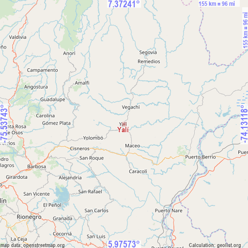
Yalí GPS coordinates[2]
6° 40' 28.452" North, 74° 50' 3.48" West
| Map corner | latitude | longitude |
|---|---|---|
| Upper-left | 7.37241°, | -75.53743° |
| Center: | 6.67457°, | -74.8343° |
| Lower-right: | 5.97573°, | -74.13118° |
| Map W x H: | 155.3×155.3 km | = 96.5×96.5mi |
| max Lat: | 13.38166° ⇑28.9% North |
| Yalí: | 6.67457° |
| min Lat: | ⇓71.1% South -4.21528° |
| min Long | Yalí | max Long |
| -81.70636° | -74.8343° | -67.06996° |
| W 49.7%⇐ | ⇒50.3% E |
Elevation
Elevation of Yalí is 1240 m = 4068 ft, and this is 90.7 m = 298 ft above average elevation for this country.
| Max E: |
3342 m = 10965 ft | 46.9% |
| Yalí | 1240 m 4068 ft | |
| Avg. | 1149.3 m = 3771 ft | |
Min E: |
1 m = 3 ft | 53.1% |
See also: Colombia elevation on elevation.city.
Geographical zone
Yalí is located in North Torrid zone (between Equator and Tropic of Cancer). Distance of Equator is 742.1 km =461.1 mi to South.| Distance of | km | miles | from Yalí |
|---|---|---|---|
| North Pole | 9264.9 | 5756.9 | to North |
| Arctic Circle | 6659 | 4137.7 | to North |
| Tropic Cancer | 1863.8 | 1158.1 | to North |
| Equator | 742.1 | 461.1 | to South |


Nearby cities:
15 places around Yalí: (largest is in red/bold)
• Alejandría
47.3 km =29.4 mi,  225°
225°
• Amalfi
37.5 km =23.3 mi,  314°
314°
• Caracolí
30.7 km =19.1 mi,  163°
163°
• Carolina
49.7 km =30.9 mi,  276°
276°
• Cisneros
31.9 km =19.8 mi,  241°
241°
• Guadalupe
47.5 km =29.5 mi,  289°
289°
• Gómez Plata
42.5 km =26.4 mi,  271°
271°
• Maceo
14.6 km =9.1 mi, 159°
• Remedios
42.3 km =26.3 mi,  21°
21°
• San Rafael
47.3 km =29.4 mi,  206°
206°
• San Roque
29.4 km =18.3 mi,  224°
224°
• Santo Domingo
42.9 km =26.7 mi, 238°
• Segovia
47.5 km =29.5 mi, 18°
• Vegachí
10.6 km =6.6 mi, 24°
• Yolombó
21.3 km =13.2 mi,  246°
246°
Sources, notices
• [Note1] Compared only with cities in Colombia existing in our database
• [Src1] Map data: © OpenStreetMap contributors (CC-BY-SA)
• [Src2] Other city data from geonames.org with taken over terms of usage.
• [Src3] Geographical zone / Annual Mean Temperature by Robert A. Rohde @ Wikipedia
