Vegachí geodata
Vegachí (Antioquia) is a seat of a second-order administrative division; located in Colombia in America/Bogota (GMT-5) time zone. With population of 9,618 people, there are 319 cities with bigger population in this country. Compared to other cities in Colombia, 72.2% of cities are located further ↓South; 50.6% of cities are located further ←West and 53.7% of cities have higher elevation than Vegachí. Note1


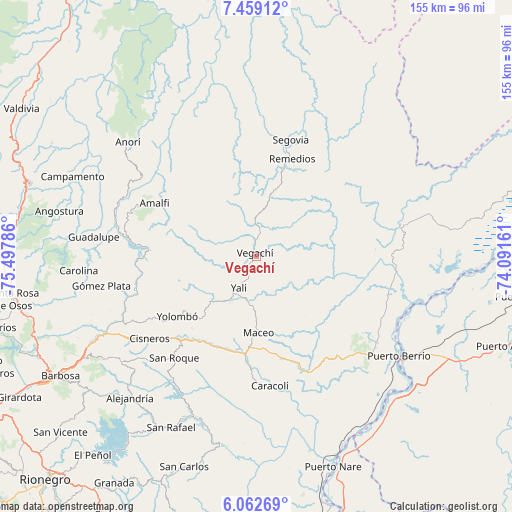
Vegachí GPS coordinates[2]
6° 45' 41.076" North, 74° 47' 41.028" West
| Map corner | latitude | longitude |
|---|---|---|
| Upper-left | 7.45912°, | -75.49786° |
| Center: | 6.76141°, | -74.79473° |
| Lower-right: | 6.06269°, | -74.09161° |
| Map W x H: | 155.3×155.3 km | = 96.5×96.5mi |
| max Lat: | 13.38166° ⇑27.8% North |
| Vegachí: | 6.76141° |
| min Lat: | ⇓72.2% South -4.21528° |
| min Long | Vegachí | max Long |
| -81.70636° | -74.79473° | -67.06996° |
| W 50.6%⇐ | ⇒49.4% E |
Elevation
Elevation of Vegachí is 993 m = 3258 ft, and this is 156.3 m = 513 ft below average elevation for this country.
| Max E: |
3342 m = 10965 ft | 53.7% |
| Avg. | 1149.3 m = 3771 ft | |
| Vegachí | 993 m = 3258 ft | |
Min E: |
1 m = 3 ft | 46.3% |
See also: Colombia elevation on elevation.city.
Geographical zone
Vegachí is located in North Torrid zone (between Equator and Tropic of Cancer). Distance of Equator is 751.8 km =467.1 mi to South.| Distance of | km | miles | from Vegachí |
|---|---|---|---|
| North Pole | 9255.3 | 5751 | to North |
| Arctic Circle | 6649.4 | 4131.7 | to North |
| Tropic Cancer | 1854.1 | 1152.1 | to North |
| Equator | 751.8 | 467.1 | to South |


Nearby cities:
15 places around Vegachí: (largest is in red/bold)
• Amalfi
35.3 km =21.9 mi,  297°
297°
• Anorí
52.1 km =32.4 mi,  311°
311°
• Caracolí
39.4 km =24.5 mi,  173°
173°
• Carolina
53.9 km =33.5 mi,  265°
265°
• Cisneros
40.8 km =25.4 mi,  232°
232°
• Guadalupe
49.6 km =30.8 mi,  276°
276°
• Gómez Plata
47.7 km =29.6 mi,  259°
259°
• Maceo
23.3 km =14.5 mi,  178°
178°
• Puerto Berrío
52.6 km =32.7 mi,  124°
124°
• Remedios
31.7 km =19.7 mi,  20°
20°
• San Roque
39.5 km =24.5 mi,  218°
218°
• Santo Domingo
52 km =32.3 mi, 231°
• Segovia
37 km =23 mi, 16°
• Yalí
10.6 km =6.6 mi,  204°
204°
• Yolombó
30 km =18.6 mi, 232°
Sources, notices
• [Note1] Compared only with cities in Colombia existing in our database
• [Src1] Map data: © OpenStreetMap contributors (CC-BY-SA)
• [Src2] Other city data from geonames.org with taken over terms of usage.
• [Src3] Geographical zone / Annual Mean Temperature by Robert A. Rohde @ Wikipedia
