Maceo geodata
Maceo (Antioquia) is a seat of a second-order administrative division; located in Colombia in America/Bogota (GMT-5) time zone. With population of 3,109 people, there are 674 cities with bigger population in this country. Compared to other cities in Colombia, 69.1% of cities are located further ↓South; 50.9% of cities are located further ←West and 56.3% of cities have higher elevation than Maceo. Note1


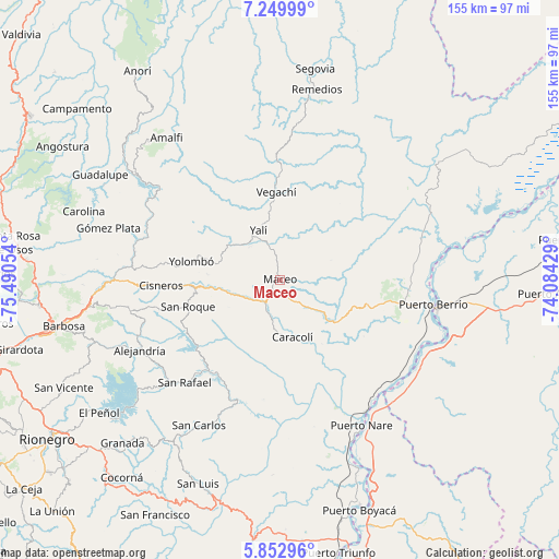
Maceo GPS coordinates[2]
6° 33' 7.056" North, 74° 47' 14.676" West
| Map corner | latitude | longitude |
|---|---|---|
| Upper-left | 7.24999°, | -75.49054° |
| Center: | 6.55196°, | -74.78741° |
| Lower-right: | 5.85296°, | -74.08429° |
| Map W x H: | 155.3×155.3 km | = 96.5×96.5mi |
| max Lat: | 13.38166° ⇑30.9% North |
| Maceo: | 6.55196° |
| min Lat: | ⇓69.1% South -4.21528° |
| min Long | Maceo | max Long |
| -81.70636° | -74.78741° | -67.06996° |
| W 50.9%⇐ | ⇒49.1% E |
Elevation
Elevation of Maceo is 951 m = 3120 ft, and this is 198.3 m = 651 ft below average elevation for this country.
| Max E: |
3342 m = 10965 ft | 56.3% |
| Avg. | 1149.3 m = 3771 ft | |
| Maceo | 951 m = 3120 ft | |
Min E: |
1 m = 3 ft | 43.7% |
See also: Colombia elevation on elevation.city.
Geographical zone
Maceo is located in North Torrid zone (between Equator and Tropic of Cancer). Distance of Equator is 728.5 km =452.7 mi to South.| Distance of | km | miles | from Maceo |
|---|---|---|---|
| North Pole | 9278.6 | 5765.5 | to North |
| Arctic Circle | 6672.7 | 4146.2 | to North |
| Tropic Cancer | 1877.4 | 1166.6 | to North |
| Equator | 728.5 | 452.7 | to South |


Nearby cities:
15 places around Maceo: (largest is in red/bold)
• Alejandría
43.6 km =27.1 mi,  243°
243°
• Amalfi
51.1 km =31.8 mi,  321°
321°
• Caracolí
16.2 km =10.1 mi,  168°
168°
• Cisneros
33.3 km =20.7 mi,  267°
267°
• Guatapé
54.5 km =33.9 mi,  229°
229°
• Gómez Plata
49.8 km =30.9 mi,  286°
286°
• Puerto Berrío
43 km =26.7 mi,  98°
98°
• Remedios
54 km =33.6 mi,  11°
11°
• San Carlos
46.4 km =28.8 mi,  209°
209°
• San Rafael
38.9 km =24.2 mi,  222°
222°
• San Roque
26.7 km =16.6 mi,  253°
253°
• Santo Domingo
42.7 km =26.5 mi,  258°
258°
• Vegachí
23.3 km =14.5 mi,  358°
358°
• Yalí
14.6 km =9.1 mi,  339°
339°
• Yolombó
25.3 km =15.7 mi,  281°
281°
Sources, notices
• [Note1] Compared only with cities in Colombia existing in our database
• [Src1] Map data: © OpenStreetMap contributors (CC-BY-SA)
• [Src2] Other city data from geonames.org with taken over terms of usage.
• [Src3] Geographical zone / Annual Mean Temperature by Robert A. Rohde @ Wikipedia
