Segovia geodata
Segovia (Antioquia) is a seat of a second-order administrative division; located in Colombia in America/Bogota (GMT-5) time zone. With population of 39,938 people, there are 99 cities with bigger population in this country. Compared to other cities in Colombia, 75.1% of cities are located further ↓South; 53.4% of cities are located further ←West and 60.9% of cities have higher elevation than Segovia. Note1


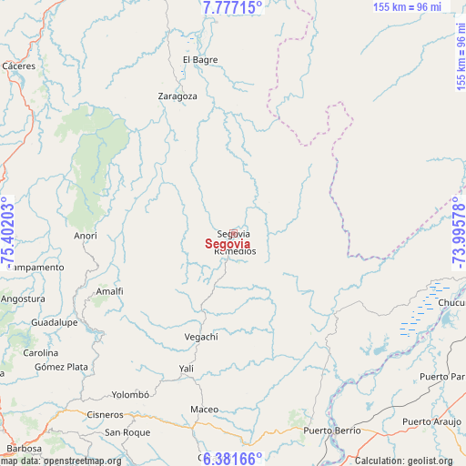
Segovia GPS coordinates[2]
7° 4' 47.748" North, 74° 41' 56.04" West
| Map corner | latitude | longitude |
|---|---|---|
| Upper-left | 7.77715°, | -75.40203° |
| Center: | 7.07993°, | -74.6989° |
| Lower-right: | 6.38166°, | -73.99578° |
| Map W x H: | 155.2×155.2 km | = 96.4×96.4mi |
| max Lat: | 13.38166° ⇑24.9% North |
| Segovia: | 7.07993° |
| min Lat: | ⇓75.1% South -4.21528° |
| min Long | Segovia | max Long |
| -81.70636° | -74.6989° | -67.06996° |
| W 53.4%⇐ | ⇒46.6% E |
Elevation
Elevation of Segovia is 680 m = 2231 ft, and this is 469.3 m = 1540 ft below average elevation for this country.
| Max E: |
3342 m = 10965 ft | 60.9% |
| Avg. | 1149.3 m = 3771 ft | |
| Segovia | 680 m = 2231 ft | |
Min E: |
1 m = 3 ft | 39.1% |
See also: Colombia elevation on elevation.city.
Geographical zone
Segovia is located in North Torrid zone (between Equator and Tropic of Cancer). Distance of Equator is 787.2 km =489.1 mi to South.| Distance of | km | miles | from Segovia |
|---|---|---|---|
| North Pole | 9219.8 | 5728.9 | to North |
| Arctic Circle | 6614 | 4109.7 | to North |
| Tropic Cancer | 1818.7 | 1130.1 | to North |
| Equator | 787.2 | 489.1 | to South |


Nearby cities:
15 places around Segovia: (largest is in red/bold)
• Amalfi
45.9 km =28.5 mi,  245°
245°
• Angostura
73.4 km =45.6 mi, 252°
• Anorí
49.5 km =30.8 mi,  269°
269°
• Campamento
67 km =41.6 mi,  260°
260°
• Cruces de Anorí
42.2 km =26.2 mi,  285°
285°
• El Bagre
59.5 km =37 mi,  348°
348°
• Guadalupe
66.7 km =41.4 mi,  243°
243°
• Gómez Plata
72.5 km =45 mi,  232°
232°
• Maceo
59.5 km =37 mi,  189°
189°
• Puerto Berrío
73.1 km =45.4 mi,  153°
153°
• Remedios
5.8 km =3.6 mi,  174°
174°
• Vegachí
37 km =23 mi,  196°
196°
• Yalí
47.5 km =29.5 mi, 198°
• Yolombó
63.7 km =39.6 mi,  212°
212°
• Zaragoza
49.3 km =30.6 mi,  337°
337°
Sources, notices
• [Note1] Compared only with cities in Colombia existing in our database
• [Src1] Map data: © OpenStreetMap contributors (CC-BY-SA)
• [Src2] Other city data from geonames.org with taken over terms of usage.
• [Src3] Geographical zone / Annual Mean Temperature by Robert A. Rohde @ Wikipedia
