Moniquirá geodata
Moniquirá (Boyacá) is a seat of a second-order administrative division; located in Colombia in America/Bogota (GMT-5) time zone. With population of 9,785 people, there are 314 cities with bigger population in this country. Compared to other cities in Colombia, 57.1% of cities are located further ↓South; 74.1% of cities are located further ←West and 67.9% of cities have lower elevation than Moniquirá. Note1


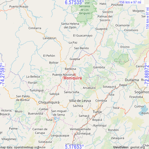
Moniquirá GPS coordinates[2]
5° 52' 34.968" North, 73° 34' 22.224" West
| Map corner | latitude | longitude |
|---|---|---|
| Upper-left | 6.57535°, | -74.27597° |
| Center: | 5.87638°, | -73.57284° |
| Lower-right: | 5.17653°, | -72.86972° |
| Map W x H: | 155.5×155.5 km | = 96.6×96.6mi |
| max Lat: | 13.38166° ⇑42.9% North |
| Moniquirá: | 5.87638° |
| min Lat: | ⇓57.1% South -4.21528° |
| min Long | Moniquirá | max Long |
| -81.70636° | -73.57284° | -67.06996° |
| W 74.1%⇐ | ⇒25.9% E |
Elevation
Elevation of Moniquirá is 1671 m = 5482 ft, and this is 521.7 m = 1712 ft above average elevation for this country.
| Max E: |
3342 m = 10965 ft | 32.1% |
| Moniquirá | 1671 m 5482 ft | |
| Avg. | 1149.3 m = 3771 ft | |
Min E: |
1 m = 3 ft | 67.9% |
See also: Colombia elevation on elevation.city.
Geographical zone
Moniquirá is located in North Torrid zone (between Equator and Tropic of Cancer). Distance of Equator is 653.4 km =406 mi to South.| Distance of | km | miles | from Moniquirá |
|---|---|---|---|
| North Pole | 9353.7 | 5812.1 | to North |
| Arctic Circle | 6747.8 | 4192.9 | to North |
| Tropic Cancer | 1952.5 | 1213.2 | to North |
| Equator | 653.4 | 406 | to South |


Nearby cities:
15 places around Moniquirá: (largest is in red/bold)
• Arcabuco
20.3 km =12.6 mi,  131°
131°
• Barbosa
7.7 km =4.8 mi,  322°
322°
• Chipatá
21.8 km =13.5 mi,  340°
340°
• Chitaraque
21.9 km =13.6 mi,  39°
39°
• Gachantivá
13.8 km =8.6 mi,  164°
164°
• Guavatá
16.6 km =10.3 mi,  301°
301°
• Güepsa
16.5 km =10.3 mi,  359°
359°
• Jesús María
23 km =14.3 mi,  270°
270°
• La Capilla
21.9 km =13.6 mi,  150°
150°
• Puente Nacional
11.6 km =7.2 mi, 270°
• San José de Pare
15.9 km =9.9 mi,  10°
10°
• Santa Sofía
18.9 km =11.7 mi,  190°
190°
• Santana
22.5 km =14 mi,  26°
26°
• Togüí
9.3 km =5.8 mi,  45°
45°
• Vélez
18.9 km =11.7 mi, 323°
Sources, notices
• [Note1] Compared only with cities in Colombia existing in our database
• [Src1] Map data: © OpenStreetMap contributors (CC-BY-SA)
• [Src2] Other city data from geonames.org with taken over terms of usage.
• [Src3] Geographical zone / Annual Mean Temperature by Robert A. Rohde @ Wikipedia
