Barbosa geodata
Barbosa (Santander) is a seat of a second-order administrative division; located in Colombia in America/Bogota (GMT-5) time zone. With population of 20,372 people, there are 175 cities with bigger population in this country. Compared to other cities in Colombia, 58% of cities are located further ↓South; 73.2% of cities are located further ←West and 64.2% of cities have lower elevation than Barbosa. Note1


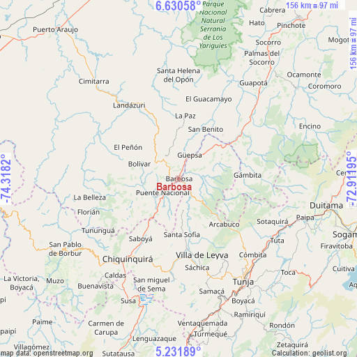
Barbosa GPS coordinates[2]
5° 55' 54.048" North, 73° 36' 54.252" West
| Map corner | latitude | longitude |
|---|---|---|
| Upper-left | 6.63058°, | -74.3182° |
| Center: | 5.93168°, | -73.61507° |
| Lower-right: | 5.23189°, | -72.91195° |
| Map W x H: | 155.5×155.5 km | = 96.6×96.6mi |
| max Lat: | 13.38166° ⇑42% North |
| Barbosa: | 5.93168° |
| min Lat: | ⇓58% South -4.21528° |
| min Long | Barbosa | max Long |
| -81.70636° | -73.61507° | -67.06996° |
| W 73.2%⇐ | ⇒26.8% E |
Elevation
Elevation of Barbosa is 1580 m = 5184 ft, and this is 430.7 m = 1413 ft above average elevation for this country.
| Max E: |
3342 m = 10965 ft | 35.8% |
| Barbosa | 1580 m 5184 ft | |
| Avg. | 1149.3 m = 3771 ft | |
Min E: |
1 m = 3 ft | 64.2% |
See also: Colombia elevation on elevation.city.
Geographical zone
Barbosa is located in North Torrid zone (between Equator and Tropic of Cancer). Distance of Equator is 659.5 km =409.8 mi to South.| Distance of | km | miles | from Barbosa |
|---|---|---|---|
| North Pole | 9347.5 | 5808.3 | to North |
| Arctic Circle | 6741.6 | 4189 | to North |
| Tropic Cancer | 1946.4 | 1209.4 | to North |
| Equator | 659.5 | 409.8 | to South |


Nearby cities:
15 places around Barbosa: (largest is in red/bold)
• Bolívar
18.4 km =11.4 mi,  290°
290°
• Chipatá
14.7 km =9.1 mi,  350°
350°
• Chitaraque
21.5 km =13.4 mi,  59°
59°
• Gachantivá
21.2 km =13.2 mi,  156°
156°
• Guavatá
9.8 km =6.1 mi, 285°
• Güepsa
11.4 km =7.1 mi,  24°
24°
• Jesús María
19.3 km =12 mi,  251°
251°
• Moniquirá
7.7 km =4.8 mi,  142°
142°
• Puente Nacional
9.2 km =5.7 mi,  229°
229°
• San José de Pare
12.1 km =7.5 mi,  38°
38°
• Santa Sofía
24.8 km =15.4 mi,  177°
177°
• Santana
20.4 km =12.7 mi,  46°
46°
• Sucre
19.5 km =12.1 mi,  265°
265°
• Togüí
11.3 km =7 mi,  88°
88°
• Vélez
11.1 km =6.9 mi,  324°
324°
Sources, notices
• [Note1] Compared only with cities in Colombia existing in our database
• [Src1] Map data: © OpenStreetMap contributors (CC-BY-SA)
• [Src2] Other city data from geonames.org with taken over terms of usage.
• [Src3] Geographical zone / Annual Mean Temperature by Robert A. Rohde @ Wikipedia
