Puente Nacional geodata
Puente Nacional (Santander) is a seat of a second-order administrative division; located in Colombia in America/Bogota (GMT-5) time zone. With population of 5,774 people, there are 461 cities with bigger population in this country. Compared to other cities in Colombia, 57.3% of cities are located further ↓South; 72% of cities are located further ←West and 66% of cities have lower elevation than Puente Nacional. Note1


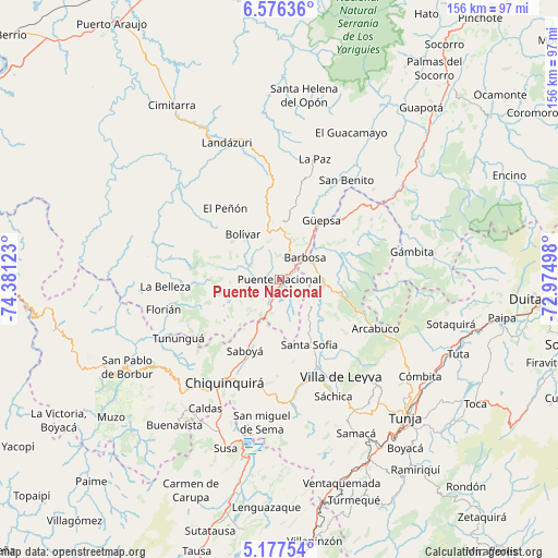
Puente Nacional GPS coordinates[2]
5° 52' 38.604" North, 73° 40' 41.16" West
| Map corner | latitude | longitude |
|---|---|---|
| Upper-left | 6.57636°, | -74.38123° |
| Center: | 5.87739°, | -73.6781° |
| Lower-right: | 5.17754°, | -72.97498° |
| Map W x H: | 155.5×155.5 km | = 96.6×96.6mi |
| max Lat: | 13.38166° ⇑42.7% North |
| Puente Nacional: | 5.87739° |
| min Lat: | ⇓57.3% South -4.21528° |
| min Long | Puente Nacional | max Long |
| -81.70636° | -73.6781° | -67.06996° |
| W 72%⇐ | ⇒28% E |
Elevation
Elevation of Puente Nacional is 1621 m = 5318 ft, and this is 471.7 m = 1548 ft above average elevation for this country.
| Max E: |
3342 m = 10965 ft | 34% |
| Puente Nacional | 1621 m 5318 ft | |
| Avg. | 1149.3 m = 3771 ft | |
Min E: |
1 m = 3 ft | 66% |
See also: Colombia elevation on elevation.city.
Geographical zone
Puente Nacional is located in North Torrid zone (between Equator and Tropic of Cancer). Distance of Equator is 653.5 km =406.1 mi to South.| Distance of | km | miles | from Puente Nacional |
|---|---|---|---|
| North Pole | 9353.6 | 5812.1 | to North |
| Arctic Circle | 6747.7 | 4192.8 | to North |
| Tropic Cancer | 1952.4 | 1213.2 | to North |
| Equator | 653.5 | 406.1 | to South |


Nearby cities:
15 places around Puente Nacional: (largest is in red/bold)
• Barbosa
9.2 km =5.7 mi,  49°
49°
• Bolívar
16.1 km =10 mi,  320°
320°
• Chipatá
21 km =13 mi,  12°
12°
• El Peñón
24.9 km =15.5 mi, 322°
• Gachantivá
20.4 km =12.7 mi,  131°
131°
• Guavatá
9 km =5.6 mi,  344°
344°
• Güepsa
20.1 km =12.5 mi,  35°
35°
• Jesús María
11.4 km =7.1 mi,  269°
269°
• Moniquirá
11.6 km =7.2 mi,  90°
90°
• Saboyá
22.5 km =14 mi,  206°
206°
• San José de Pare
21.3 km =13.2 mi, 42°
• Santa Sofía
20.4 km =12.7 mi,  156°
156°
• Sucre
13.3 km =8.3 mi,  290°
290°
• Togüí
19.3 km =12 mi,  70°
70°
• Vélez
15.1 km =9.4 mi,  1°
1°
Sources, notices
• [Note1] Compared only with cities in Colombia existing in our database
• [Src1] Map data: © OpenStreetMap contributors (CC-BY-SA)
• [Src2] Other city data from geonames.org with taken over terms of usage.
• [Src3] Geographical zone / Annual Mean Temperature by Robert A. Rohde @ Wikipedia
