Togüí geodata
Togüí (Boyacá) is a seat of a second-order administrative division; located in Colombia in America/Bogota (GMT-5) time zone. With population of 829 people, there are 973 cities with bigger population in this country. Compared to other cities in Colombia, 58.1% of cities are located further ↓South; 75.1% of cities are located further ←West and 74.9% of cities have lower elevation than Togüí. Note1


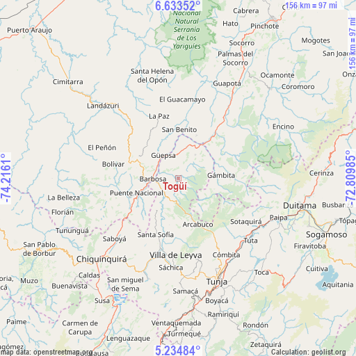
Togüí GPS coordinates[2]
5° 56' 4.632" North, 73° 30' 46.692" West
| Map corner | latitude | longitude |
|---|---|---|
| Upper-left | 6.63352°, | -74.2161° |
| Center: | 5.93462°, | -73.51297° |
| Lower-right: | 5.23484°, | -72.80985° |
| Map W x H: | 155.5×155.5 km | = 96.6×96.6mi |
| max Lat: | 13.38166° ⇑41.9% North |
| Togüí: | 5.93462° |
| min Lat: | ⇓58.1% South -4.21528° |
| min Long | Togüí | max Long |
| -81.70636° | -73.51297° | -67.06996° |
| W 75.1%⇐ | ⇒24.9% E |
Elevation
Elevation of Togüí is 1831 m = 6007 ft, and this is 681.7 m = 2237 ft above average elevation for this country.
| Max E: |
3342 m = 10965 ft | 25.1% |
| Togüí | 1831 m 6007 ft | |
| Avg. | 1149.3 m = 3771 ft | |
Min E: |
1 m = 3 ft | 74.9% |
See also: Colombia elevation on elevation.city.
Geographical zone
Togüí is located in North Torrid zone (between Equator and Tropic of Cancer). Distance of Equator is 659.9 km =410 mi to South.| Distance of | km | miles | from Togüí |
|---|---|---|---|
| North Pole | 9347.2 | 5808.1 | to North |
| Arctic Circle | 6741.3 | 4188.8 | to North |
| Tropic Cancer | 1946.1 | 1209.3 | to North |
| Equator | 659.9 | 410 | to South |


Nearby cities:
15 places around Togüí: (largest is in red/bold)
• Arcabuco
21.7 km =13.5 mi,  157°
157°
• Barbosa
11.3 km =7 mi,  268°
268°
• Chipatá
19.7 km =12.2 mi,  315°
315°
• Chitaraque
12.7 km =7.9 mi,  34°
34°
• Gachantivá
20 km =12.4 mi,  188°
188°
• Guavatá
20.8 km =12.9 mi,  276°
276°
• Gámbita
18.7 km =11.6 mi,  86°
86°
• Güepsa
12.1 km =7.5 mi,  326°
326°
• Moniquirá
9.3 km =5.8 mi,  225°
225°
• Puente Nacional
19.3 km =12 mi,  250°
250°
• San Benito
22.2 km =13.8 mi,  6°
6°
• San José de Pare
10 km =6.2 mi,  337°
337°
• Santana
14.1 km =8.8 mi, 14°
• Suaita
20.2 km =12.6 mi,  23°
23°
• Vélez
19.8 km =12.3 mi,  296°
296°
Sources, notices
• [Note1] Compared only with cities in Colombia existing in our database
• [Src1] Map data: © OpenStreetMap contributors (CC-BY-SA)
• [Src2] Other city data from geonames.org with taken over terms of usage.
• [Src3] Geographical zone / Annual Mean Temperature by Robert A. Rohde @ Wikipedia
