Turbo geodata
Turbo (Antioquia) is a seat of a second-order administrative division; located in Colombia in America/Bogota (GMT-5) time zone. With population of 50,508 people, there are 80 cities with bigger population in this country. Compared to other cities in Colombia, 81.4% of cities are located further ↓South; 89.9% of cities are located further →East and 98.5% of cities have higher elevation than Turbo. Note1


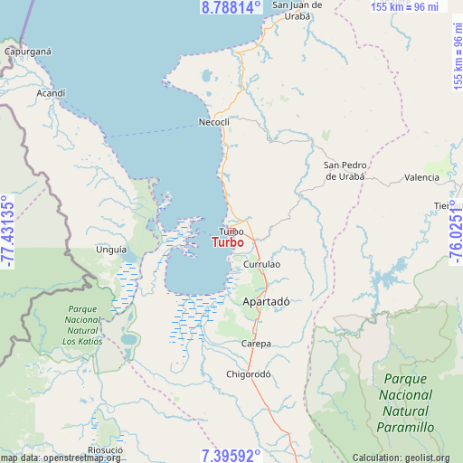
Turbo GPS coordinates[2]
8° 5' 33.468" North, 76° 43' 41.592" West
| Map corner | latitude | longitude |
|---|---|---|
| Upper-left | 8.78814°, | -77.43135° |
| Center: | 8.09263°, | -76.72822° |
| Lower-right: | 7.39592°, | -76.0251° |
| Map W x H: | 154.8×154.8 km | = 96.2×96.2mi |
| max Lat: | 13.38166° ⇑18.6% North |
| Turbo: | 8.09263° |
| min Lat: | ⇓81.4% South -4.21528° |
| min Long | Turbo | max Long |
| -81.70636° | -76.72822° | -67.06996° |
| W 10.1%⇐ | ⇒89.9% E |
Elevation
Elevation of Turbo is 6 m = 20 ft, and this is 1143.3 m = 3751 ft below average elevation for this country.
| Max E: |
3342 m = 10965 ft | 98.5% |
| Avg. | 1149.3 m = 3771 ft | |
| Turbo | 6 m = 20 ft | |
Min E: |
1 m = 3 ft | 1.5% |
See also: Turbo elevation on elevation.city.
Geographical zone
Turbo is located in North Torrid zone (between Equator and Tropic of Cancer). Distance of Equator is 899.8 km =559.1 mi to South.| Distance of | km | miles | from Turbo |
|---|---|---|---|
| North Pole | 9107.2 | 5658.9 | to North |
| Arctic Circle | 6501.4 | 4039.8 | to North |
| Tropic Cancer | 1706.1 | 1060.1 | to North |
| Equator | 899.8 | 559.1 | to South |


Nearby cities:
15 places around Turbo: (largest is in red/bold)
• Acandí
76.3 km =47.4 mi,  307°
307°
• Apartadó
25.9 km =16.1 mi,  154°
154°
• Arboletes
90.5 km =56.2 mi,  21°
21°
• Canalete
86.8 km =53.9 mi,  41°
41°
• Canalete
93.9 km =58.3 mi,  34°
34°
• Carepa
38.1 km =23.7 mi,  167°
167°
• Chigorodó
47.7 km =29.6 mi, 173°
• Moñitos
76.7 km =47.7 mi,  76°
76°
• Necoclí
37.7 km =23.4 mi,  349°
349°
• Riosucio
84.1 km =52.3 mi,  210°
210°
• San Juan de Urabá
77.3 km =48 mi, 16°
• San Pedro de Urabá
43.7 km =27.2 mi,  62°
62°
• Tierralta
74.2 km =46.1 mi, 83°
• Unguía
40.3 km =25 mi,  262°
262°
• Valencia
66.3 km =41.2 mi,  73°
73°
Sources, notices
• [Note1] Compared only with cities in Colombia existing in our database
• [Src1] Map data: © OpenStreetMap contributors (CC-BY-SA)
• [Src2] Other city data from geonames.org with taken over terms of usage.
• [Src3] Geographical zone / Annual Mean Temperature by Robert A. Rohde @ Wikipedia
