Tununguá geodata
Tununguá (Boyacá) is a seat of a second-order administrative division; located in Colombia in America/Bogota (GMT-5) time zone. With population of 178 people, there are 1050 cities with bigger population in this country. Compared to other cities in Colombia, 54.6% of cities are located further ↓South; 66.4% of cities are located further ←West and 50.8% of cities have lower elevation than Tununguá. Note1


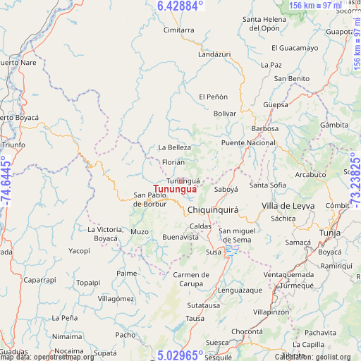
Tununguá GPS coordinates[2]
5° 43' 46.812" North, 73° 56' 28.932" West
| Map corner | latitude | longitude |
|---|---|---|
| Upper-left | 6.42884°, | -74.6445° |
| Center: | 5.72967°, | -73.94137° |
| Lower-right: | 5.02965°, | -73.23825° |
| Map W x H: | 155.6×155.6 km | = 96.7×96.7mi |
| max Lat: | 13.38166° ⇑45.4% North |
| Tununguá: | 5.72967° |
| min Lat: | ⇓54.6% South -4.21528° |
| min Long | Tununguá | max Long |
| -81.70636° | -73.94137° | -67.06996° |
| W 66.4%⇐ | ⇒33.6% E |
Elevation
Elevation of Tununguá is 1150 m = 3773 ft, and this is 0.70000000000005 m = 2 ft above average elevation for this country.
| Max E: |
3342 m = 10965 ft | 49.2% |
| Tununguá | 1150 m 3773 ft | |
| Avg. | 1149.3 m = 3771 ft | |
Min E: |
1 m = 3 ft | 50.8% |
See also: Colombia elevation on elevation.city.
Geographical zone
Tununguá is located in North Torrid zone (between Equator and Tropic of Cancer). Distance of Equator is 637.1 km =395.9 mi to South.| Distance of | km | miles | from Tununguá |
|---|---|---|---|
| North Pole | 9370 | 5822.2 | to North |
| Arctic Circle | 6764.1 | 4203 | to North |
| Tropic Cancer | 1968.8 | 1223.4 | to North |
| Equator | 637.1 | 395.9 | to South |


Nearby cities:
15 places around Tununguá: (largest is in red/bold)
• Albania
4.5 km =2.8 mi,  43°
43°
• Briceño
5.3 km =3.3 mi,  150°
150°
• Buenavista
24 km =14.9 mi,  182°
182°
• Caldas
21.2 km =13.2 mi,  156°
156°
• Chiquinquirá
18.6 km =11.6 mi,  132°
132°
• Florián
9 km =5.6 mi,  339°
339°
• Jesús María
24.2 km =15 mi,  47°
47°
• La Belleza
15.1 km =9.4 mi,  351°
351°
• Maripí
21.1 km =13.1 mi,  200°
200°
• Otanche
27.9 km =17.3 mi,  253°
253°
• Pauna
9.1 km =5.7 mi,  209°
209°
• Saboyá
19.4 km =12.1 mi,  101°
101°
• San Pablo de Borbur
16.7 km =10.4 mi,  238°
238°
• Simijaca
27.1 km =16.8 mi, 158°
• Sucre
26.8 km =16.7 mi, 38°
Sources, notices
• [Note1] Compared only with cities in Colombia existing in our database
• [Src1] Map data: © OpenStreetMap contributors (CC-BY-SA)
• [Src2] Other city data from geonames.org with taken over terms of usage.
• [Src3] Geographical zone / Annual Mean Temperature by Robert A. Rohde @ Wikipedia
