Chiquinquirá geodata
Chiquinquirá (Boyacá) is a seat of a second-order administrative division; located in Colombia in America/Bogota (GMT-5) time zone. With population of 45,294 people, there are 89 cities with bigger population in this country. Compared to other cities in Colombia, 52.5% of cities are located further ↓South; 69.1% of cities are located further ←West and 90.9% of cities have lower elevation than Chiquinquirá. Note1


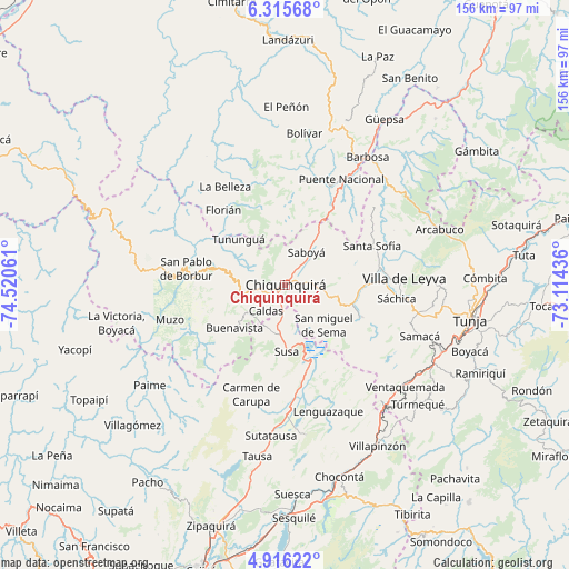
Chiquinquirá GPS coordinates[2]
5° 36' 58.932" North, 73° 49' 2.928" West
| Map corner | latitude | longitude |
|---|---|---|
| Upper-left | 6.31568°, | -74.52061° |
| Center: | 5.61637°, | -73.81748° |
| Lower-right: | 4.91622°, | -73.11436° |
| Map W x H: | 155.6×155.6 km | = 96.7×96.7mi |
| max Lat: | 13.38166° ⇑47.5% North |
| Chiquinquirá: | 5.61637° |
| min Lat: | ⇓52.5% South -4.21528° |
| min Long | Chiquinquirá | max Long |
| -81.70636° | -73.81748° | -67.06996° |
| W 69.1%⇐ | ⇒30.9% E |
Elevation
Elevation of Chiquinquirá is 2562 m = 8406 ft, and this is 1412.7 m = 4635 ft above average elevation for this country.
| Max E: |
3342 m = 10965 ft | 9.1% |
| Chiquinquirá | 2562 m 8406 ft | |
| Avg. | 1149.3 m = 3771 ft | |
Min E: |
1 m = 3 ft | 90.9% |
See also: Chiquinquirá elevation on elevation.city.
Geographical zone
Chiquinquirá is located in North Torrid zone (between Equator and Tropic of Cancer). Distance of Equator is 624.5 km =388 mi to South.| Distance of | km | miles | from Chiquinquirá |
|---|---|---|---|
| North Pole | 9382.6 | 5830.1 | to North |
| Arctic Circle | 6776.7 | 4210.8 | to North |
| Tropic Cancer | 1981.4 | 1231.2 | to North |
| Equator | 624.5 | 388 | to South |


Nearby cities:
15 places around Chiquinquirá: (largest is in red/bold)
• Albania
19.1 km =11.9 mi,  326°
326°
• Briceño
13.7 km =8.5 mi,  305°
305°
• Buenavista
18.5 km =11.5 mi,  231°
231°
• Caldas
8.7 km =5.4 mi,  217°
217°
• Fúquene
23.7 km =14.7 mi,  174°
174°
• Maripí
22.3 km =13.9 mi,  251°
251°
• Pauna
18.9 km =11.7 mi,  284°
284°
• Ráquira
22.3 km =13.9 mi,  113°
113°
• Saboyá
10.4 km =6.5 mi,  30°
30°
• San Miguel de Sema
15.1 km =9.4 mi,  135°
135°
• Simijaca
13.2 km =8.2 mi,  196°
196°
• Susa
18.3 km =11.4 mi,  178°
178°
• Sutamarchán
22.2 km =13.8 mi,  90°
90°
• Tinjacá
19.5 km =12.1 mi,  102°
102°
• Tununguá
18.6 km =11.6 mi, 312°
Sources, notices
• [Note1] Compared only with cities in Colombia existing in our database
• [Src1] Map data: © OpenStreetMap contributors (CC-BY-SA)
• [Src2] Other city data from geonames.org with taken over terms of usage.
• [Src3] Geographical zone / Annual Mean Temperature by Robert A. Rohde @ Wikipedia
