Pauna geodata
Pauna (Boyacá) is a seat of a second-order administrative division; located in Colombia in America/Bogota (GMT-5) time zone. With population of 2,663 people, there are 720 cities with bigger population in this country. Compared to other cities in Colombia, 53.3% of cities are located further ↓South; 65.2% of cities are located further ←West and 51.2% of cities have higher elevation than Pauna. Note1


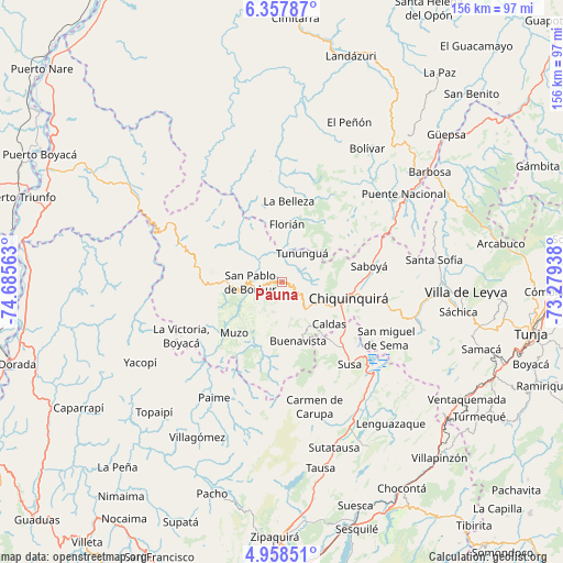
Pauna GPS coordinates[2]
5° 39' 30.996" North, 73° 58' 57" West
| Map corner | latitude | longitude |
|---|---|---|
| Upper-left | 6.35787°, | -74.68563° |
| Center: | 5.65861°, | -73.9825° |
| Lower-right: | 4.95851°, | -73.27938° |
| Map W x H: | 155.6×155.6 km | = 96.7×96.7mi |
| max Lat: | 13.38166° ⇑46.7% North |
| Pauna: | 5.65861° |
| min Lat: | ⇓53.3% South -4.21528° |
| min Long | Pauna | max Long |
| -81.70636° | -73.9825° | -67.06996° |
| W 65.2%⇐ | ⇒34.8% E |
Elevation
Elevation of Pauna is 1080 m = 3543 ft, and this is 69.3 m = 227 ft below average elevation for this country.
| Max E: |
3342 m = 10965 ft | 51.2% |
| Avg. | 1149.3 m = 3771 ft | |
| Pauna | 1080 m = 3543 ft | |
Min E: |
1 m = 3 ft | 48.8% |
See also: Colombia elevation on elevation.city.
Geographical zone
Pauna is located in North Torrid zone (between Equator and Tropic of Cancer). Distance of Equator is 629.2 km =391 mi to South.| Distance of | km | miles | from Pauna |
|---|---|---|---|
| North Pole | 9377.9 | 5827.2 | to North |
| Arctic Circle | 6772 | 4207.9 | to North |
| Tropic Cancer | 1976.7 | 1228.3 | to North |
| Equator | 629.2 | 391 | to South |


Nearby cities:
15 places around Pauna: (largest is in red/bold)
• Albania
13.5 km =8.4 mi,  34°
34°
• Briceño
7.9 km =4.9 mi,  65°
65°
• Buenavista
16.5 km =10.3 mi,  167°
167°
• Caldas
17.3 km =10.7 mi,  131°
131°
• Chiquinquirá
18.9 km =11.7 mi,  104°
104°
• Coper
21.3 km =13.2 mi,  198°
198°
• Florián
16.3 km =10.1 mi,  4°
4°
• La Belleza
22.9 km =14.2 mi,  5°
5°
• Maripí
12.2 km =7.6 mi,  193°
193°
• Muzo
19.5 km =12.1 mi,  225°
225°
• Otanche
22.1 km =13.7 mi,  269°
269°
• Saboyá
24 km =14.9 mi,  79°
79°
• San Pablo de Borbur
9.7 km =6 mi, 265°
• Simijaca
22.5 km =14 mi,  140°
140°
• Tununguá
9.1 km =5.7 mi, 29°
Sources, notices
• [Note1] Compared only with cities in Colombia existing in our database
• [Src1] Map data: © OpenStreetMap contributors (CC-BY-SA)
• [Src2] Other city data from geonames.org with taken over terms of usage.
• [Src3] Geographical zone / Annual Mean Temperature by Robert A. Rohde @ Wikipedia
