Briceño geodata
Briceño (Boyacá) is a seat of a second-order administrative division; located in Colombia in America/Bogota (GMT-5) time zone. With population of 632 people, there are 1010 cities with bigger population in this country. Compared to other cities in Colombia, 53.6% of cities are located further ↓South; 66.9% of cities are located further ←West and 57% of cities have lower elevation than Briceño. Note1


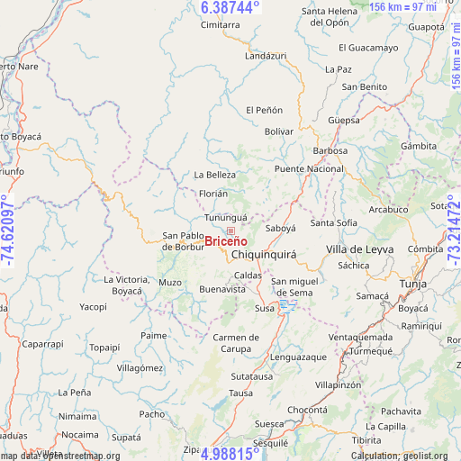
Briceño GPS coordinates[2]
5° 41' 17.592" North, 73° 55' 4.224" West
| Map corner | latitude | longitude |
|---|---|---|
| Upper-left | 6.38744°, | -74.62097° |
| Center: | 5.68822°, | -73.91784° |
| Lower-right: | 4.98815°, | -73.21472° |
| Map W x H: | 155.6×155.6 km | = 96.7×96.7mi |
| max Lat: | 13.38166° ⇑46.4% North |
| Briceño: | 5.68822° |
| min Lat: | ⇓53.6% South -4.21528° |
| min Long | Briceño | max Long |
| -81.70636° | -73.91784° | -67.06996° |
| W 66.9%⇐ | ⇒33.1% E |
Elevation
Elevation of Briceño is 1358 m = 4455 ft, and this is 208.7 m = 685 ft above average elevation for this country.
| Max E: |
3342 m = 10965 ft | 43% |
| Briceño | 1358 m 4455 ft | |
| Avg. | 1149.3 m = 3771 ft | |
Min E: |
1 m = 3 ft | 57% |
See also: Colombia elevation on elevation.city.
Geographical zone
Briceño is located in North Torrid zone (between Equator and Tropic of Cancer). Distance of Equator is 632.5 km =393 mi to South.| Distance of | km | miles | from Briceño |
|---|---|---|---|
| North Pole | 9374.6 | 5825.1 | to North |
| Arctic Circle | 6768.7 | 4205.9 | to North |
| Tropic Cancer | 1973.4 | 1226.2 | to North |
| Equator | 632.5 | 393 | to South |


Nearby cities:
15 places around Briceño: (largest is in red/bold)
• Albania
7.9 km =4.9 mi,  3°
3°
• Buenavista
19.7 km =12.2 mi,  190°
190°
• Caldas
15.9 km =9.9 mi,  158°
158°
• Chiquinquirá
13.7 km =8.5 mi,  125°
125°
• Coper
27.3 km =17 mi,  210°
210°
• Florián
14.2 km =8.8 mi,  335°
335°
• Jesús María
25.9 km =16.1 mi,  35°
35°
• La Belleza
20.1 km =12.5 mi,  346°
346°
• Maripí
18.2 km =11.3 mi, 213°
• Muzo
27 km =16.8 mi,  231°
231°
• Pauna
7.9 km =4.9 mi,  245°
245°
• Saboyá
16.5 km =10.3 mi,  86°
86°
• San Pablo de Borbur
17.3 km =10.7 mi,  256°
256°
• Simijaca
21.8 km =13.5 mi, 160°
• Tununguá
5.3 km =3.3 mi,  330°
330°
Sources, notices
• [Note1] Compared only with cities in Colombia existing in our database
• [Src1] Map data: © OpenStreetMap contributors (CC-BY-SA)
• [Src2] Other city data from geonames.org with taken over terms of usage.
• [Src3] Geographical zone / Annual Mean Temperature by Robert A. Rohde @ Wikipedia
