Saboyá geodata
Saboyá (Boyacá) is a seat of a second-order administrative division; located in Colombia in America/Bogota (GMT-5) time zone. With population of 1,375 people, there are 888 cities with bigger population in this country. Compared to other cities in Colombia, 53.8% of cities are located further ↓South; 70.6% of cities are located further ←West and 94.3% of cities have lower elevation than Saboyá. Note1


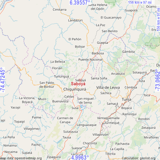
Saboyá GPS coordinates[2]
5° 41' 46.896" North, 73° 46' 9.552" West
| Map corner | latitude | longitude |
|---|---|---|
| Upper-left | 6.39557°, | -74.47245° |
| Center: | 5.69636°, | -73.76932° |
| Lower-right: | 4.9963°, | -73.0662° |
| Map W x H: | 155.6×155.6 km | = 96.7×96.7mi |
| max Lat: | 13.38166° ⇑46.2% North |
| Saboyá: | 5.69636° |
| min Lat: | ⇓53.8% South -4.21528° |
| min Long | Saboyá | max Long |
| -81.70636° | -73.76932° | -67.06996° |
| W 70.6%⇐ | ⇒29.4% E |
Elevation
Elevation of Saboyá is 2640 m = 8661 ft, and this is 1490.7 m = 4891 ft above average elevation for this country.
| Max E: |
3342 m = 10965 ft | 5.7% |
| Saboyá | 2640 m 8661 ft | |
| Avg. | 1149.3 m = 3771 ft | |
Min E: |
1 m = 3 ft | 94.3% |
See also: Colombia elevation on elevation.city.
Geographical zone
Saboyá is located in North Torrid zone (between Equator and Tropic of Cancer). Distance of Equator is 633.4 km =393.6 mi to South.| Distance of | km | miles | from Saboyá |
|---|---|---|---|
| North Pole | 9373.7 | 5824.5 | to North |
| Arctic Circle | 6767.8 | 4205.3 | to North |
| Tropic Cancer | 1972.5 | 1225.7 | to North |
| Equator | 633.4 | 393.6 | to South |


Nearby cities:
15 places around Saboyá: (largest is in red/bold)
• Albania
17.4 km =10.8 mi,  293°
293°
• Briceño
16.5 km =10.3 mi,  266°
266°
• Caldas
19 km =11.8 mi,  214°
214°
• Chiquinquirá
10.4 km =6.5 mi, 210°
• Jesús María
20.1 km =12.5 mi,  356°
356°
• Pauna
24 km =14.9 mi,  259°
259°
• Puente Nacional
22.5 km =14 mi,  26°
26°
• Ráquira
23.3 km =14.5 mi,  139°
139°
• San Miguel de Sema
20.5 km =12.7 mi,  165°
165°
• Santa Sofía
18.3 km =11.4 mi,  85°
85°
• Simijaca
23.4 km =14.5 mi,  203°
203°
• Sucre
24.8 km =15.4 mi,  354°
354°
• Sutamarchán
19.1 km =11.9 mi,  118°
118°
• Tinjacá
19 km =11.8 mi,  133°
133°
• Tununguá
19.4 km =12.1 mi,  281°
281°
Sources, notices
• [Note1] Compared only with cities in Colombia existing in our database
• [Src1] Map data: © OpenStreetMap contributors (CC-BY-SA)
• [Src2] Other city data from geonames.org with taken over terms of usage.
• [Src3] Geographical zone / Annual Mean Temperature by Robert A. Rohde @ Wikipedia
