Caldas geodata
Caldas (Boyacá) is a seat of a second-order administrative division; located in Colombia in America/Bogota (GMT-5) time zone. With population of 475 people, there are 1029 cities with bigger population in this country. Compared to other cities in Colombia, 50.9% of cities are located further ↓South; 68.3% of cities are located further ←West and 94.9% of cities have lower elevation than Caldas. Note1


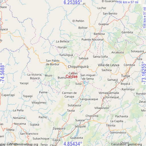
Caldas GPS coordinates[2]
5° 33' 16.416" North, 73° 51' 56.412" West
| Map corner | latitude | longitude |
|---|---|---|
| Upper-left | 6.25395°, | -74.5688° |
| Center: | 5.55456°, | -73.86567° |
| Lower-right: | 4.85434°, | -73.16255° |
| Map W x H: | 155.6×155.6 km | = 96.7×96.7mi |
| max Lat: | 13.38166° ⇑49.1% North |
| Caldas: | 5.55456° |
| min Lat: | ⇓50.9% South -4.21528° |
| min Long | Caldas | max Long |
| -81.70636° | -73.86567° | -67.06996° |
| W 68.3%⇐ | ⇒31.7% E |
Elevation
Elevation of Caldas is 2671 m = 8763 ft, and this is 1521.7 m = 4992 ft above average elevation for this country.
| Max E: |
3342 m = 10965 ft | 5.1% |
| Caldas | 2671 m 8763 ft | |
| Avg. | 1149.3 m = 3771 ft | |
Min E: |
1 m = 3 ft | 94.9% |
See also: Colombia elevation on elevation.city.
Geographical zone
Caldas is located in North Torrid zone (between Equator and Tropic of Cancer). Distance of Equator is 617.6 km =383.8 mi to South.| Distance of | km | miles | from Caldas |
|---|---|---|---|
| North Pole | 9389.5 | 5834.4 | to North |
| Arctic Circle | 6783.6 | 4215.1 | to North |
| Tropic Cancer | 1988.3 | 1235.5 | to North |
| Equator | 617.6 | 383.8 | to South |


Nearby cities:
15 places around Caldas: (largest is in red/bold)
• Albania
23.3 km =14.5 mi,  346°
346°
• Briceño
15.9 km =9.9 mi,  338°
338°
• Buenavista
10.3 km =6.4 mi,  243°
243°
• Carmen de Carupa
23.2 km =14.4 mi,  189°
189°
• Chiquinquirá
8.7 km =5.4 mi,  37°
37°
• Coper
21.6 km =13.4 mi,  246°
246°
• Fúquene
18.4 km =11.4 mi,  155°
155°
• Maripí
15.8 km =9.8 mi,  268°
268°
• Pauna
17.3 km =10.7 mi,  311°
311°
• Saboyá
19 km =11.8 mi,  34°
34°
• San Miguel de Sema
16.4 km =10.2 mi,  104°
104°
• Simijaca
5.9 km =3.7 mi,  165°
165°
• Susa
12.7 km =7.9 mi,  153°
153°
• Tinjacá
24.6 km =15.3 mi,  83°
83°
• Tununguá
21.2 km =13.2 mi, 336°
Sources, notices
• [Note1] Compared only with cities in Colombia existing in our database
• [Src1] Map data: © OpenStreetMap contributors (CC-BY-SA)
• [Src2] Other city data from geonames.org with taken over terms of usage.
• [Src3] Geographical zone / Annual Mean Temperature by Robert A. Rohde @ Wikipedia
