San Pablo de Borbur geodata
San Pablo de Borbur (Boyacá) is a seat of a second-order administrative division; located in Colombia in America/Bogota (GMT-5) time zone. With population of 1,519 people, there are 862 cities with bigger population in this country. Compared to other cities in Colombia, 53% of cities are located further ↓South; 63.5% of cities are located further ←West and 58.1% of cities have higher elevation than San Pablo de Borbur. Note1


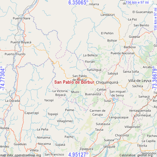
San Pablo de Borbur GPS coordinates[2]
5° 39' 4.968" North, 74° 4' 11.676" West
| Map corner | latitude | longitude |
|---|---|---|
| Upper-left | 6.35065°, | -74.77304° |
| Center: | 5.65138°, | -74.06991° |
| Lower-right: | 4.95127°, | -73.36679° |
| Map W x H: | 155.6×155.6 km | = 96.7×96.7mi |
| max Lat: | 13.38166° ⇑47% North |
| San Pablo de Borbur: | 5.65138° |
| min Lat: | ⇓53% South -4.21528° |
| min Long | San Pablo de Bo | max Long |
| -81.70636° | -74.06991° | -67.06996° |
| W 63.5%⇐ | ⇒36.5% E |
Elevation
Elevation of San Pablo de Borbur is 885 m = 2904 ft, and this is 264.3 m = 867 ft below average elevation for this country.
| Max E: |
3342 m = 10965 ft | 58.1% |
| Avg. | 1149.3 m = 3771 ft | |
| San Pablo de Borbur | 885 m = 2904 ft | |
Min E: |
1 m = 3 ft | 41.9% |
See also: Colombia elevation on elevation.city.
Geographical zone
San Pablo de Borbur is located in North Torrid zone (between Equator and Tropic of Cancer). Distance of Equator is 628.4 km =390.5 mi to South.| Distance of | km | miles | from San Pablo de Borbur |
|---|---|---|---|
| North Pole | 9378.7 | 5827.7 | to North |
| Arctic Circle | 6772.8 | 4208.4 | to North |
| Tropic Cancer | 1977.5 | 1228.8 | to North |
| Equator | 628.4 | 390.5 | to South |


Nearby cities:
15 places around San Pablo de Borbur: (largest is in red/bold)
• Albania
21 km =13 mi,  55°
55°
• Briceño
17.3 km =10.7 mi,  76°
76°
• Buenavista
20.3 km =12.6 mi,  138°
138°
• Caldas
25 km =15.5 mi,  115°
115°
• Chiquinquirá
28.2 km =17.5 mi,  97°
97°
• Coper
19.6 km =12.2 mi,  171°
171°
• Florián
20.3 km =12.6 mi,  32°
32°
• La Belleza
26.5 km =16.5 mi, 26°
• La Victoria
23.1 km =14.4 mi,  232°
232°
• Maripí
13 km =8.1 mi,  148°
148°
• Muzo
13.6 km =8.5 mi,  197°
197°
• Otanche
12.5 km =7.8 mi,  272°
272°
• Pauna
9.7 km =6 mi,  85°
85°
• Quípama
18.9 km =11.7 mi,  219°
219°
• Tununguá
16.7 km =10.4 mi, 58°
Sources, notices
• [Note1] Compared only with cities in Colombia existing in our database
• [Src1] Map data: © OpenStreetMap contributors (CC-BY-SA)
• [Src2] Other city data from geonames.org with taken over terms of usage.
• [Src3] Geographical zone / Annual Mean Temperature by Robert A. Rohde @ Wikipedia
