Hacarí geodata
Hacarí (Norte de Santander) is a seat of a second-order administrative division; located in Colombia in America/Bogota (GMT-5) time zone. With population of 1,502 people, there are 864 cities with bigger population in this country. Compared to other cities in Colombia, 82.9% of cities are located further ↓South; 83.8% of cities are located further ←West and 53.4% of cities have lower elevation than Hacarí. Note1


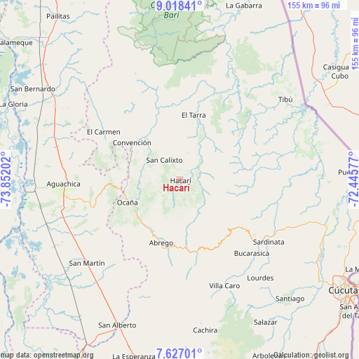
Hacarí GPS coordinates[2]
8° 19' 23.988" North, 73° 8' 56.004" West
| Map corner | latitude | longitude |
|---|---|---|
| Upper-left | 9.01841°, | -73.85202° |
| Center: | 8.32333°, | -73.14889° |
| Lower-right: | 7.62701°, | -72.44577° |
| Map W x H: | 154.7×154.7 km | = 96.1×96.1mi |
| max Lat: | 13.38166° ⇑17.1% North |
| Hacarí: | 8.32333° |
| min Lat: | ⇓82.9% South -4.21528° |
| min Long | Hacarí | max Long |
| -81.70636° | -73.14889° | -67.06996° |
| W 83.8%⇐ | ⇒16.2% E |
Elevation
Elevation of Hacarí is 1247 m = 4091 ft, and this is 97.7 m = 321 ft above average elevation for this country.
| Max E: |
3342 m = 10965 ft | 46.6% |
| Hacarí | 1247 m 4091 ft | |
| Avg. | 1149.3 m = 3771 ft | |
Min E: |
1 m = 3 ft | 53.4% |
See also: Colombia elevation on elevation.city.
Geographical zone
Hacarí is located in North Torrid zone (between Equator and Tropic of Cancer). Distance of Equator is 925.5 km =575.1 mi to South.| Distance of | km | miles | from Hacarí |
|---|---|---|---|
| North Pole | 9081.6 | 5643 | to North |
| Arctic Circle | 6475.7 | 4023.8 | to North |
| Tropic Cancer | 1680.5 | 1044.2 | to North |
| Equator | 925.5 | 575.1 | to South |


Nearby cities:
15 places around Hacarí: (largest is in red/bold)
• Aguachica
51.5 km =32 mi,  268°
268°
• Bucarasica
44.3 km =27.5 mi,  135°
135°
• Convención
26.3 km =16.3 mi,  307°
307°
• El Carmen
38.9 km =24.2 mi,  302°
302°
• El Tarra
28.7 km =17.8 mi,  11°
11°
• González
26.5 km =16.5 mi,  286°
286°
• La Playa
15.7 km =9.8 mi,  218°
218°
• Ocaña
24.7 km =15.3 mi,  247°
247°
• Río de Oro
26.2 km =16.3 mi,  262°
262°
• San Calixto
10.9 km =6.8 mi,  323°
323°
• San Martín
53.6 km =33.3 mi,  228°
228°
• Sardinata
46.7 km =29 mi,  124°
124°
• Teorama
20 km =12.4 mi, 309°
• Villa Caro
49.5 km =30.8 mi,  156°
156°
• Ábrego
28.1 km =17.5 mi,  196°
196°
Sources, notices
• [Note1] Compared only with cities in Colombia existing in our database
• [Src1] Map data: © OpenStreetMap contributors (CC-BY-SA)
• [Src2] Other city data from geonames.org with taken over terms of usage.
• [Src3] Geographical zone / Annual Mean Temperature by Robert A. Rohde @ Wikipedia
