San Diego geodata
San Diego (Cesar) is a seat of a second-order administrative division; located in Colombia in America/Bogota (GMT-5) time zone. With population of 8,014 people, there are 368 cities with bigger population in this country. Compared to other cities in Colombia, 94.7% of cities are located further ↓South; 83.1% of cities are located further ←West and 76.1% of cities have higher elevation than San Diego. Note1


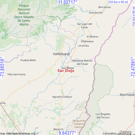
San Diego GPS coordinates[2]
10° 20' 10.428" North, 73° 10' 55.308" West
| Map corner | latitude | longitude |
|---|---|---|
| Upper-left | 11.02717°, | -73.88516° |
| Center: | 10.33623°, | -73.18203° |
| Lower-right: | 9.64377°, | -72.47891° |
| Map W x H: | 153.8×153.8 km | = 95.6×95.6mi |
| max Lat: | 13.38166° ⇑5.3% North |
| San Diego: | 10.33623° |
| min Lat: | ⇓94.7% South -4.21528° |
| min Long | San Diego | max Long |
| -81.70636° | -73.18203° | -67.06996° |
| W 83.1%⇐ | ⇒16.9% E |
Elevation
Elevation of San Diego is 166 m = 545 ft, and this is 983.3 m = 3226 ft below average elevation for this country.
| Max E: |
3342 m = 10965 ft | 76.1% |
| Avg. | 1149.3 m = 3771 ft | |
| San Diego | 166 m = 545 ft | |
Min E: |
1 m = 3 ft | 23.9% |
See also: Colombia elevation on elevation.city.
Geographical zone
San Diego is located in North Torrid zone (between Equator and Tropic of Cancer). Distance of Equator is 1149.3 km =714.1 mi to South.| Distance of | km | miles | from San Diego |
|---|---|---|---|
| North Pole | 8857.8 | 5504 | to North |
| Arctic Circle | 6251.9 | 3884.7 | to North |
| Tropic Cancer | 1456.6 | 905.1 | to North |
| Equator | 1149.3 | 714.1 | to South |


Nearby cities:
15 places around San Diego: (largest is in red/bold)
• Agustín Codazzi
33.8 km =21 mi,  189°
189°
• Barrancas
80.9 km =50.3 mi,  31°
31°
• Becerril
71.1 km =44.2 mi, 188°
• Bosconia
87.3 km =54.2 mi,  242°
242°
• Distracción
70.3 km =43.7 mi, 27°
• El Molino
45.1 km =28 mi,  38°
38°
• Fonseca
71.2 km =44.2 mi, 30°
• La Jagua del Pilar
22.8 km =14.2 mi, 31°
• La Paz
5.4 km =3.4 mi,  10°
10°
• Manaure Balcón del Cesar
17.5 km =10.9 mi,  68°
68°
• Pueblo Bello
44.5 km =27.7 mi,  281°
281°
• San Juan del Cesar
52.2 km =32.4 mi,  22°
22°
• Urumita
30.9 km =19.2 mi, 36°
• Valledupar
16.1 km =10 mi,  331°
331°
• Villanueva
37.5 km =23.3 mi, 36°
Sources, notices
• [Note1] Compared only with cities in Colombia existing in our database
• [Src1] Map data: © OpenStreetMap contributors (CC-BY-SA)
• [Src2] Other city data from geonames.org with taken over terms of usage.
• [Src3] Geographical zone / Annual Mean Temperature by Robert A. Rohde @ Wikipedia
