Valledupar geodata
Valledupar (Cesar) is a seat of a first-order administrative division; located in Colombia in America/Bogota (GMT-5) time zone. With population of 308,237 people, there are 18 cities with bigger population in this country. Compared to other cities in Colombia, 96% of cities are located further ↓South; 81.5% of cities are located further ←West and 76.4% of cities have higher elevation than Valledupar. Note1


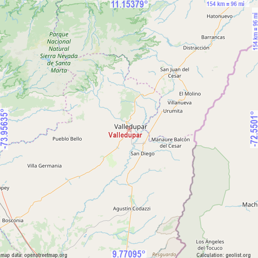
Valledupar GPS coordinates[2]
10° 27' 47.304" North, 73° 15' 11.592" West
| Map corner | latitude | longitude |
|---|---|---|
| Upper-left | 11.15379°, | -73.95635° |
| Center: | 10.46314°, | -73.25322° |
| Lower-right: | 9.77095°, | -72.5501° |
| Map W x H: | 153.8×153.8 km | = 95.6×95.6mi |
| max Lat: | 13.38166° ⇑4% North |
| Valledupar: | 10.46314° |
| min Lat: | ⇓96% South -4.21528° |
| min Long | Valledupar | max Long |
| -81.70636° | -73.25322° | -67.06996° |
| W 81.5%⇐ | ⇒18.5% E |
Elevation
Elevation of Valledupar is 165 m = 541 ft, and this is 984.3 m = 3229 ft below average elevation for this country.
| Max E: |
3342 m = 10965 ft | 76.4% |
| Avg. | 1149.3 m = 3771 ft | |
| Valledupar | 165 m = 541 ft | |
Min E: |
1 m = 3 ft | 23.6% |
See also: Valledupar elevation on elevation.city.
Geographical zone
Valledupar is located in North Torrid zone (between Equator and Tropic of Cancer). Distance of Equator is 1163.4 km =722.9 mi to South.| Distance of | km | miles | from Valledupar |
|---|---|---|---|
| North Pole | 8843.7 | 5495.2 | to North |
| Arctic Circle | 6237.8 | 3876 | to North |
| Tropic Cancer | 1442.5 | 896.3 | to North |
| Equator | 1163.4 | 722.9 | to South |


Nearby cities:
15 places around Valledupar: (largest is in red/bold)
• Agustín Codazzi
47.5 km =29.5 mi,  177°
177°
• Barrancas
74.3 km =46.2 mi,  42°
42°
• Becerril
84.4 km =52.4 mi, 181°
• Distracción
62.8 km =39 mi, 39°
• El Copey
84.9 km =52.8 mi,  245°
245°
• El Molino
41.7 km =25.9 mi,  59°
59°
• Fonseca
64.5 km =40.1 mi, 43°
• La Jagua del Pilar
20.5 km =12.7 mi,  75°
75°
• La Paz
12.4 km =7.7 mi,  135°
135°
• Manaure Balcón del Cesar
25.4 km =15.8 mi,  107°
107°
• Pueblo Bello
36.1 km =22.4 mi,  261°
261°
• San Diego
16.1 km =10 mi,  151°
151°
• San Juan del Cesar
43.8 km =27.2 mi, 38°
• Urumita
28.4 km =17.6 mi,  67°
67°
• Villanueva
34 km =21.1 mi, 61°
Sources, notices
• [Note1] Compared only with cities in Colombia existing in our database
• [Src1] Map data: © OpenStreetMap contributors (CC-BY-SA)
• [Src2] Other city data from geonames.org with taken over terms of usage.
• [Src3] Geographical zone / Annual Mean Temperature by Robert A. Rohde @ Wikipedia
