San Juan del Cesar geodata
San Juan del Cesar (La Guajira) is a seat of a second-order administrative division; located in Colombia in America/Bogota (GMT-5) time zone. With population of 26,848 people, there are 137 cities with bigger population in this country. Compared to other cities in Colombia, 97.8% of cities are located further ↓South; 86.4% of cities are located further ←West and 73.7% of cities have higher elevation than San Juan del Cesar. Note1


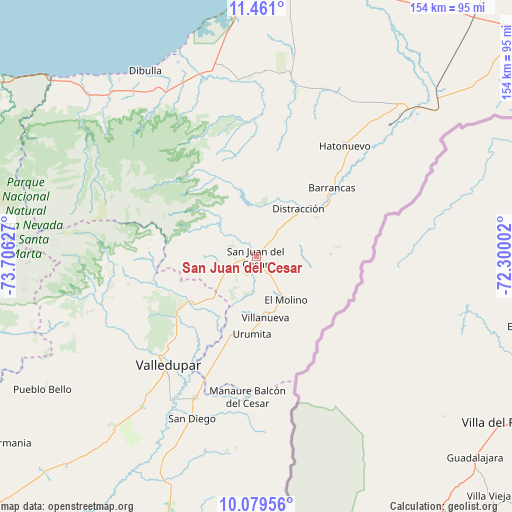
San Juan del Cesar GPS coordinates[2]
10° 46' 15.852" North, 73° 0' 11.304" West
| Map corner | latitude | longitude |
|---|---|---|
| Upper-left | 11.461°, | -73.70627° |
| Center: | 10.77107°, | -73.00314° |
| Lower-right: | 10.07956°, | -72.30002° |
| Map W x H: | 153.6×153.6 km | = 95.4×95.4mi |
| max Lat: | 13.38166° ⇑2.2% North |
| San Juan del Cesar: | 10.77107° |
| min Lat: | ⇓97.8% South -4.21528° |
| min Long | San Juan del Ce | max Long |
| -81.70636° | -73.00314° | -67.06996° |
| W 86.4%⇐ | ⇒13.6% E |
Elevation
Elevation of San Juan del Cesar is 214 m = 702 ft, and this is 935.3 m = 3069 ft below average elevation for this country.
| Max E: |
3342 m = 10965 ft | 73.7% |
| Avg. | 1149.3 m = 3771 ft | |
| San Juan del Cesar | 214 m = 702 ft | |
Min E: |
1 m = 3 ft | 26.3% |
See also: Colombia elevation on elevation.city.
Geographical zone
San Juan del Cesar is located in North Torrid zone (between Equator and Tropic of Cancer). Distance of Equator is 1197.6 km =744.2 mi to South.| Distance of | km | miles | from San Juan del Cesar |
|---|---|---|---|
| North Pole | 8809.4 | 5473.9 | to North |
| Arctic Circle | 6203.5 | 3854.7 | to North |
| Tropic Cancer | 1408.3 | 875.1 | to North |
| Equator | 1197.6 | 744.2 | to South |


Nearby cities:
15 places around San Juan del Cesar: (largest is in red/bold)
• Agustín Codazzi
85.5 km =53.1 mi,  197°
197°
• Albania
62.4 km =38.8 mi,  45°
45°
• Barrancas
30.7 km =19.1 mi, 47°
• Dibulla
65 km =40.4 mi,  329°
329°
• Distracción
19 km =11.8 mi,  42°
42°
• El Molino
15.7 km =9.8 mi,  146°
146°
• Fonseca
21.2 km =13.2 mi, 52°
• La Jagua del Pilar
29.9 km =18.6 mi,  194°
194°
• La Paz
46.8 km =29.1 mi, 203°
• Manaure Balcón del Cesar
42.2 km =26.2 mi,  184°
184°
• Pueblo Bello
74.4 km =46.2 mi,  238°
238°
• San Diego
52.2 km =32.4 mi, 202°
• Urumita
23.6 km =14.7 mi, 182°
• Valledupar
43.8 km =27.2 mi,  218°
218°
• Villanueva
18.4 km =11.4 mi,  171°
171°
Sources, notices
• [Note1] Compared only with cities in Colombia existing in our database
• [Src1] Map data: © OpenStreetMap contributors (CC-BY-SA)
• [Src2] Other city data from geonames.org with taken over terms of usage.
• [Src3] Geographical zone / Annual Mean Temperature by Robert A. Rohde @ Wikipedia
