Villanueva geodata
Villanueva (La Guajira) is a seat of a second-order administrative division; located in Colombia in America/Bogota (GMT-5) time zone. With population of 18,699 people, there are 192 cities with bigger population in this country. Compared to other cities in Colombia, 96.7% of cities are located further ↓South; 87% of cities are located further ←West and 70.8% of cities have higher elevation than Villanueva. Note1


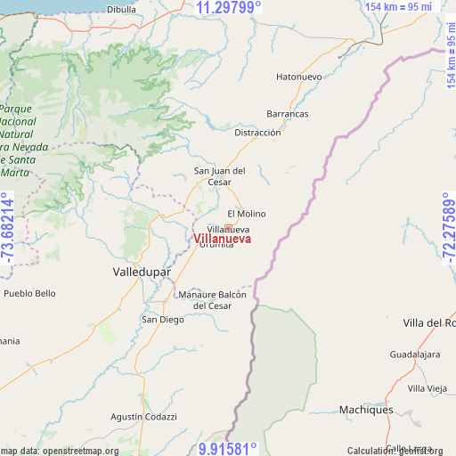
Villanueva GPS coordinates[2]
10° 36' 27.648" North, 72° 58' 44.436" West
| Map corner | latitude | longitude |
|---|---|---|
| Upper-left | 11.29799°, | -73.68214° |
| Center: | 10.60768°, | -72.97901° |
| Lower-right: | 9.91581°, | -72.27589° |
| Map W x H: | 153.7×153.7 km | = 95.5×95.5mi |
| max Lat: | 13.38166° ⇑3.3% North |
| Villanueva: | 10.60768° |
| min Lat: | ⇓96.7% South -4.21528° |
| min Long | Villanueva | max Long |
| -81.70636° | -72.97901° | -67.06996° |
| W 87%⇐ | ⇒13% E |
Elevation
Elevation of Villanueva is 279 m = 915 ft, and this is 870.3 m = 2855 ft below average elevation for this country.
| Max E: |
3342 m = 10965 ft | 70.8% |
| Avg. | 1149.3 m = 3771 ft | |
| Villanueva | 279 m = 915 ft | |
Min E: |
1 m = 3 ft | 29.2% |
See also: Colombia elevation on elevation.city.
Geographical zone
Villanueva is located in North Torrid zone (between Equator and Tropic of Cancer). Distance of Equator is 1179.5 km =732.9 mi to South.| Distance of | km | miles | from Villanueva |
|---|---|---|---|
| North Pole | 8827.6 | 5485.2 | to North |
| Arctic Circle | 6221.7 | 3866 | to North |
| Tropic Cancer | 1426.5 | 886.4 | to North |
| Equator | 1179.5 | 732.9 | to South |


Nearby cities:
15 places around Villanueva: (largest is in red/bold)
• Agustín Codazzi
69.4 km =43.1 mi,  203°
203°
• Albania
74.6 km =46.4 mi,  34°
34°
• Barrancas
43.7 km =27.2 mi, 27°
• Dibulla
82.2 km =51.1 mi,  334°
334°
• Distracción
33.8 km =21 mi,  17°
17°
• El Molino
7.8 km =4.8 mi,  49°
49°
• Fonseca
34.1 km =21.2 mi, 24°
• La Jagua del Pilar
14.8 km =9.2 mi,  223°
223°
• La Paz
32.7 km =20.3 mi, 220°
• Manaure Balcón del Cesar
24.6 km =15.3 mi,  193°
193°
• Pueblo Bello
69.1 km =42.9 mi,  252°
252°
• San Diego
37.5 km =23.3 mi, 216°
• San Juan del Cesar
18.4 km =11.4 mi,  351°
351°
• Urumita
6.5 km =4 mi,  213°
213°
• Valledupar
34 km =21.1 mi,  241°
241°
Sources, notices
• [Note1] Compared only with cities in Colombia existing in our database
• [Src1] Map data: © OpenStreetMap contributors (CC-BY-SA)
• [Src2] Other city data from geonames.org with taken over terms of usage.
• [Src3] Geographical zone / Annual Mean Temperature by Robert A. Rohde @ Wikipedia
