Fonseca geodata
Fonseca (La Guajira) is a seat of a second-order administrative division; located in Colombia in America/Bogota (GMT-5) time zone. With population of 23,509 people, there are 153 cities with bigger population in this country. Compared to other cities in Colombia, 98.5% of cities are located further ↓South; 89.7% of cities are located further ←West and 75.1% of cities have higher elevation than Fonseca. Note1


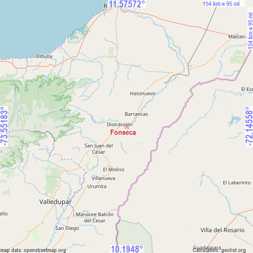
Fonseca GPS coordinates[2]
10° 53' 9.816" North, 72° 50' 55.32" West
| Map corner | latitude | longitude |
|---|---|---|
| Upper-left | 11.57572°, | -73.55183° |
| Center: | 10.88606°, | -72.8487° |
| Lower-right: | 10.1948°, | -72.14558° |
| Map W x H: | 153.5×153.5 km | = 95.4×95.4mi |
| max Lat: | 13.38166° ⇑1.5% North |
| Fonseca: | 10.88606° |
| min Lat: | ⇓98.5% South -4.21528° |
| min Long | Fonseca | max Long |
| -81.70636° | -72.8487° | -67.06996° |
| W 89.7%⇐ | ⇒10.3% E |
Elevation
Elevation of Fonseca is 182 m = 597 ft, and this is 967.3 m = 3174 ft below average elevation for this country.
| Max E: |
3342 m = 10965 ft | 75.1% |
| Avg. | 1149.3 m = 3771 ft | |
| Fonseca | 182 m = 597 ft | |
Min E: |
1 m = 3 ft | 24.9% |
See also: Colombia elevation on elevation.city.
Geographical zone
Fonseca is located in North Torrid zone (between Equator and Tropic of Cancer). Distance of Equator is 1210.4 km =752.1 mi to South.| Distance of | km | miles | from Fonseca |
|---|---|---|---|
| North Pole | 8796.6 | 5466 | to North |
| Arctic Circle | 6190.8 | 3846.8 | to North |
| Tropic Cancer | 1395.5 | 867.1 | to North |
| Equator | 1210.4 | 752.1 | to South |


Nearby cities:
15 places around Fonseca: (largest is in red/bold)
• Albania
41.4 km =25.7 mi,  42°
42°
• Barrancas
9.8 km =6.1 mi, 36°
• Dibulla
66.1 km =41.1 mi,  310°
310°
• Distracción
4.3 km =2.7 mi,  287°
287°
• El Molino
27.2 km =16.9 mi,  197°
197°
• La Jagua del Pilar
48.3 km =30 mi,  210°
210°
• La Paz
66.1 km =41.1 mi, 212°
• Maicao
86.1 km =53.5 mi,  50°
50°
• Manaure Balcón del Cesar
58.4 km =36.3 mi, 200°
• Riohacha
73.5 km =45.7 mi,  355°
355°
• San Diego
71.2 km =44.2 mi, 210°
• San Juan del Cesar
21.2 km =13.2 mi,  232°
232°
• Urumita
40.5 km =25.2 mi, 206°
• Valledupar
64.5 km =40.1 mi,  223°
223°
• Villanueva
34.1 km =21.2 mi, 204°
Sources, notices
• [Note1] Compared only with cities in Colombia existing in our database
• [Src1] Map data: © OpenStreetMap contributors (CC-BY-SA)
• [Src2] Other city data from geonames.org with taken over terms of usage.
• [Src3] Geographical zone / Annual Mean Temperature by Robert A. Rohde @ Wikipedia
