Villa de Leyva geodata
Villa de Leyva (Boyacá) is a seat of a second-order administrative division; located in Colombia in America/Bogota (GMT-5) time zone. With population of 5,103 people, there are 501 cities with bigger population in this country. Compared to other cities in Colombia, 52.9% of cities are located further ↓South; 74.8% of cities are located further ←West and 81.6% of cities have lower elevation than Villa de Leyva. Note1


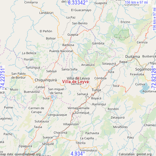
Villa de Leyva GPS coordinates[2]
5° 38' 2.868" North, 73° 31' 27.768" West
| Map corner | latitude | longitude |
|---|---|---|
| Upper-left | 6.33342°, | -74.22751° |
| Center: | 5.63413°, | -73.52438° |
| Lower-right: | 4.934°, | -72.82126° |
| Map W x H: | 155.6×155.6 km | = 96.7×96.7mi |
| max Lat: | 13.38166° ⇑47.1% North |
| Villa de Leyva: | 5.63413° |
| min Lat: | ⇓52.9% South -4.21528° |
| min Long | Villa de Leyva | max Long |
| -81.70636° | -73.52438° | -67.06996° |
| W 74.8%⇐ | ⇒25.2% E |
Elevation
Elevation of Villa de Leyva is 2119 m = 6952 ft, and this is 969.7 m = 3181 ft above average elevation for this country.
| Max E: |
3342 m = 10965 ft | 18.4% |
| Villa de Leyva | 2119 m 6952 ft | |
| Avg. | 1149.3 m = 3771 ft | |
Min E: |
1 m = 3 ft | 81.6% |
See also: Colombia elevation on elevation.city.
Geographical zone
Villa de Leyva is located in North Torrid zone (between Equator and Tropic of Cancer). Distance of Equator is 626.5 km =389.3 mi to South.| Distance of | km | miles | from Villa de Leyva |
|---|---|---|---|
| North Pole | 9380.6 | 5828.8 | to North |
| Arctic Circle | 6774.7 | 4209.6 | to North |
| Tropic Cancer | 1979.5 | 1230 | to North |
| Equator | 626.5 | 389.3 | to South |


Nearby cities:
15 places around Villa de Leyva: (largest is in red/bold)
• Arcabuco
16.5 km =10.3 mi,  35°
35°
• Chíquiza
5.5 km =3.4 mi,  127°
127°
• Cucaita
12.7 km =7.9 mi,  142°
142°
• Cómbita
22.2 km =13.8 mi,  90°
90°
• Gachantivá
13.7 km =8.5 mi,  352°
352°
• La Capilla
9.6 km =6 mi,  34°
34°
• Motavita
18.6 km =11.6 mi,  110°
110°
• Ráquira
16 km =9.9 mi,  228°
228°
• Samacá
16.3 km =10.1 mi,  164°
164°
• Santa Sofía
12.1 km =7.5 mi,  313°
313°
• Sora
11.2 km =7 mi, 133°
• Sutamarchán
10.5 km =6.5 mi,  258°
258°
• Sáchica
5.8 km =3.6 mi,  199°
199°
• Tinjacá
14.7 km =9.1 mi,  245°
245°
• Tunja
20.5 km =12.7 mi,  122°
122°
Sources, notices
• [Note1] Compared only with cities in Colombia existing in our database
• [Src1] Map data: © OpenStreetMap contributors (CC-BY-SA)
• [Src2] Other city data from geonames.org with taken over terms of usage.
• [Src3] Geographical zone / Annual Mean Temperature by Robert A. Rohde @ Wikipedia
