Sáchica geodata
Sáchica (Boyacá) is a seat of a second-order administrative division; located in Colombia in America/Bogota (GMT-5) time zone. With population of 1,774 people, there are 826 cities with bigger population in this country. Compared to other cities in Colombia, 51.8% of cities are located further ↓South; 74.4% of cities are located further ←West and 82.6% of cities have lower elevation than Sáchica. Note1


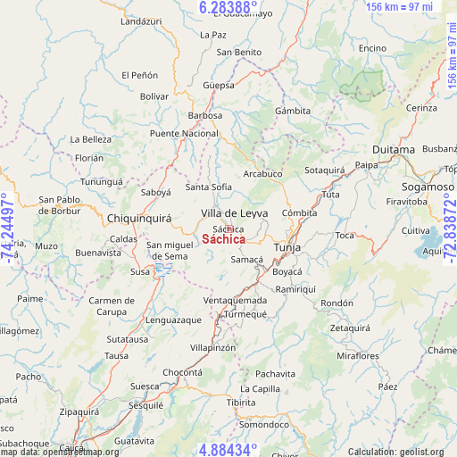
Sáchica GPS coordinates[2]
5° 35' 4.308" North, 73° 32' 30.624" West
| Map corner | latitude | longitude |
|---|---|---|
| Upper-left | 6.28388°, | -74.24497° |
| Center: | 5.58453°, | -73.54184° |
| Lower-right: | 4.88434°, | -72.83872° |
| Map W x H: | 155.6×155.6 km | = 96.7×96.7mi |
| max Lat: | 13.38166° ⇑48.2% North |
| Sáchica: | 5.58453° |
| min Lat: | ⇓51.8% South -4.21528° |
| min Long | Sáchica | max Long |
| -81.70636° | -73.54184° | -67.06996° |
| W 74.4%⇐ | ⇒25.6% E |
Elevation
Elevation of Sáchica is 2153 m = 7064 ft, and this is 1003.7 m = 3293 ft above average elevation for this country.
| Max E: |
3342 m = 10965 ft | 17.4% |
| Sáchica | 2153 m 7064 ft | |
| Avg. | 1149.3 m = 3771 ft | |
Min E: |
1 m = 3 ft | 82.6% |
See also: Colombia elevation on elevation.city.
Geographical zone
Sáchica is located in North Torrid zone (between Equator and Tropic of Cancer). Distance of Equator is 620.9 km =385.8 mi to South.| Distance of | km | miles | from Sáchica |
|---|---|---|---|
| North Pole | 9386.1 | 5832.3 | to North |
| Arctic Circle | 6780.2 | 4213 | to North |
| Tropic Cancer | 1985 | 1233.4 | to North |
| Equator | 620.9 | 385.8 | to South |


Nearby cities:
15 places around Sáchica: (largest is in red/bold)
• Arcabuco
22.2 km =13.8 mi,  31°
31°
• Chíquiza
6.6 km =4.1 mi,  70°
70°
• Cucaita
10.7 km =6.6 mi,  115°
115°
• Gachantivá
19.1 km =11.9 mi,  0°
0°
• La Capilla
15.3 km =9.5 mi, 28°
• Motavita
19.4 km =12.1 mi,  92°
92°
• Ráquira
11.2 km =7 mi,  242°
242°
• Samacá
12 km =7.5 mi,  148°
148°
• San Miguel de Sema
21.3 km =13.2 mi,  249°
249°
• Santa Sofía
15.5 km =9.6 mi,  333°
333°
• Sora
10.4 km =6.5 mi,  101°
101°
• Sutamarchán
9 km =5.6 mi,  292°
292°
• Tinjacá
11.4 km =7.1 mi,  267°
267°
• Tunja
20 km =12.4 mi,  105°
105°
• Villa de Leyva
5.8 km =3.6 mi,  19°
19°
Sources, notices
• [Note1] Compared only with cities in Colombia existing in our database
• [Src1] Map data: © OpenStreetMap contributors (CC-BY-SA)
• [Src2] Other city data from geonames.org with taken over terms of usage.
• [Src3] Geographical zone / Annual Mean Temperature by Robert A. Rohde @ Wikipedia
