Puerto Lleras geodata
Puerto Lleras (Meta) is a populated place; located in Colombia in America/Bogota (GMT-5) time zone. With population of 5,076 people, there are 502 cities with bigger population in this country. Compared to other cities in Colombia, 84.1% of cities are located further ↑North; 77.7% of cities are located further ←West and 72.2% of cities have higher elevation than Puerto Lleras. Note1


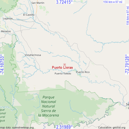
Puerto Lleras GPS coordinates[2]
3° 1' 20.1" North, 73° 24' 15.84" West
| Map corner | latitude | longitude |
|---|---|---|
| Upper-left | 3.72415°, | -74.10753° |
| Center: | 3.02225°, | -73.4044° |
| Lower-right: | 2.31989°, | -72.70128° |
| Map W x H: | 156.1×156.1 km | = 97×97mi |
| max Lat: | 13.38166° ⇑84.1% North |
| Puerto Lleras: | 3.02225° |
| min Lat: | ⇓15.9% South -4.21528° |
| min Long | Puerto Lleras | max Long |
| -81.70636° | -73.4044° | -67.06996° |
| W 77.7%⇐ | ⇒22.3% E |
Elevation
Elevation of Puerto Lleras is 251 m = 823 ft, and this is 898.3 m = 2947 ft below average elevation for this country.
| Max E: |
3342 m = 10965 ft | 72.2% |
| Avg. | 1149.3 m = 3771 ft | |
| Puerto Lleras | 251 m = 823 ft | |
Min E: |
1 m = 3 ft | 27.8% |
See also: Colombia elevation on elevation.city.
Geographical zone
Puerto Lleras is located in North Torrid zone (between Equator and Tropic of Cancer). Distance of Equator is 336 km =208.8 mi to South.| Distance of | km | miles | from Puerto Lleras |
|---|---|---|---|
| North Pole | 9671 | 6009.3 | to North |
| Arctic Circle | 7065.1 | 4390 | to North |
| Tropic Cancer | 2269.9 | 1410.5 | to North |
| Equator | 336 | 208.8 | to South |


Nearby cities:
15 places around Puerto Lleras: (largest is in red/bold)
• Castilla La Nueva
94.9 km =59 mi,  340°
340°
• El Castillo
74.2 km =46.1 mi,  324°
324°
• El Dorado
65.6 km =40.8 mi,  114°
114°
• El Dorado
92.9 km =57.7 mi,  329°
329°
• Fuente de Oro
54.6 km =33.9 mi, 333°
• Granada
67.2 km =41.8 mi, 330°
• Lejanías
88.8 km =55.2 mi,  309°
309°
• Mesetas
81.7 km =50.8 mi,  299°
299°
• Puerto Concordia
84.5 km =52.5 mi,  121°
121°
• Puerto Lleras
27.7 km =17.2 mi,  6°
6°
• Puerto Yuca
23.7 km =14.7 mi, 113°
• San Carlos de Guaroa
78.7 km =48.9 mi, 13°
• San Juan de Arama
64.8 km =40.3 mi, 306°
• San Martín
81.8 km =50.8 mi, 336°
• Vistahermosa
40.2 km =25 mi,  286°
286°
Sources, notices
• [Note1] Compared only with cities in Colombia existing in our database
• [Src1] Map data: © OpenStreetMap contributors (CC-BY-SA)
• [Src2] Other city data from geonames.org with taken over terms of usage.
• [Src3] Geographical zone / Annual Mean Temperature by Robert A. Rohde @ Wikipedia
