San Martín geodata
San Martín (Meta) is a seat of a second-order administrative division; located in Colombia in America/Bogota (GMT-5) time zone. With population of 16,273 people, there are 213 cities with bigger population in this country. Compared to other cities in Colombia, 80.4% of cities are located further ↑North; 71.6% of cities are located further ←West and 65.5% of cities have higher elevation than San Martín. Note1


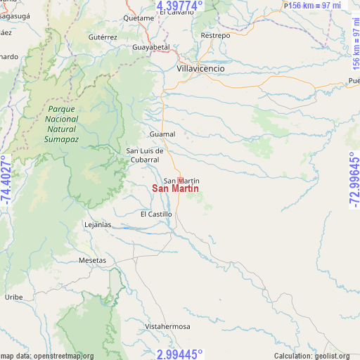
San Martín GPS coordinates[2]
3° 41' 46.932" North, 73° 41' 58.452" West
| Map corner | latitude | longitude |
|---|---|---|
| Upper-left | 4.39774°, | -74.4027° |
| Center: | 3.69637°, | -73.69957° |
| Lower-right: | 2.99445°, | -72.99645° |
| Map W x H: | 156×156 km | = 96.9×96.9mi |
| max Lat: | 13.38166° ⇑80.4% North |
| San Martín: | 3.69637° |
| min Lat: | ⇓19.6% South -4.21528° |
| min Long | San Martín | max Long |
| -81.70636° | -73.69957° | -67.06996° |
| W 71.6%⇐ | ⇒28.4% E |
Elevation
Elevation of San Martín is 425 m = 1394 ft, and this is 724.3 m = 2376 ft below average elevation for this country.
| Max E: |
3342 m = 10965 ft | 65.5% |
| Avg. | 1149.3 m = 3771 ft | |
| San Martín | 425 m = 1394 ft | |
Min E: |
1 m = 3 ft | 34.5% |
See also: Colombia elevation on elevation.city.
Geographical zone
San Martín is located in North Torrid zone (between Equator and Tropic of Cancer). Distance of Equator is 411 km =255.4 mi to South.| Distance of | km | miles | from San Martín |
|---|---|---|---|
| North Pole | 9596.1 | 5962.7 | to North |
| Arctic Circle | 6990.2 | 4343.5 | to North |
| Tropic Cancer | 2194.9 | 1363.8 | to North |
| Equator | 411 | 255.4 | to South |


Nearby cities:
15 places around San Martín: (largest is in red/bold)
• Acacías
33 km =20.5 mi,  348°
348°
• Castilla La Nueva
14.6 km =9.1 mi,  4°
4°
• Cubarral
19.1 km =11.9 mi,  305°
305°
• El Castillo
18.2 km =11.3 mi,  215°
215°
• El Dorado
15.8 km =9.8 mi,  287°
287°
• Fuente de Oro
27.4 km =17 mi,  161°
161°
• Granada
16.7 km =10.4 mi,  182°
182°
• Guamal
21.7 km =13.5 mi,  340°
340°
• Guayabetal
59.1 km =36.7 mi, 347°
• Lejanías
40.5 km =25.2 mi,  242°
242°
• Mesetas
51.6 km =32.1 mi,  227°
227°
• Puerto Lleras
59.6 km =37 mi,  142°
142°
• San Carlos de Guaroa
50.6 km =31.4 mi,  88°
88°
• San Juan de Arama
41.1 km =25.5 mi,  207°
207°
• Villavicencio
50.2 km =31.2 mi,  9°
9°
Sources, notices
• [Note1] Compared only with cities in Colombia existing in our database
• [Src1] Map data: © OpenStreetMap contributors (CC-BY-SA)
• [Src2] Other city data from geonames.org with taken over terms of usage.
• [Src3] Geographical zone / Annual Mean Temperature by Robert A. Rohde @ Wikipedia
