El Castillo geodata
El Castillo (Meta) is a seat of a second-order administrative division; located in Colombia in America/Bogota (GMT-5) time zone. With population of 2,581 people, there are 732 cities with bigger population in this country. Compared to other cities in Colombia, 81.1% of cities are located further ↑North; 70.1% of cities are located further ←West and 67.3% of cities have higher elevation than El Castillo. Note1


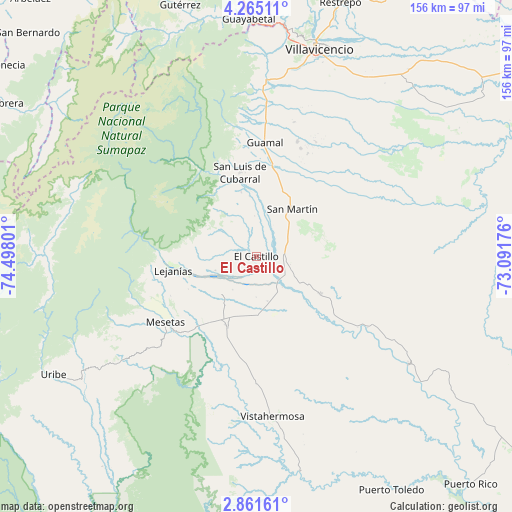
El Castillo GPS coordinates[2]
3° 33' 49.068" North, 73° 47' 41.568" West
| Map corner | latitude | longitude |
|---|---|---|
| Upper-left | 4.26511°, | -74.49801° |
| Center: | 3.56363°, | -73.79488° |
| Lower-right: | 2.86161°, | -73.09176° |
| Map W x H: | 156.1×156.1 km | = 97×97mi |
| max Lat: | 13.38166° ⇑81.1% North |
| El Castillo: | 3.56363° |
| min Lat: | ⇓18.9% South -4.21528° |
| min Long | El Castillo | max Long |
| -81.70636° | -73.79488° | -67.06996° |
| W 70.1%⇐ | ⇒29.9% E |
Elevation
Elevation of El Castillo is 350 m = 1148 ft, and this is 799.3 m = 2622 ft below average elevation for this country.
| Max E: |
3342 m = 10965 ft | 67.3% |
| Avg. | 1149.3 m = 3771 ft | |
| El Castillo | 350 m = 1148 ft | |
Min E: |
1 m = 3 ft | 32.7% |
See also: Colombia elevation on elevation.city.
Geographical zone
El Castillo is located in North Torrid zone (between Equator and Tropic of Cancer). Distance of Equator is 396.2 km =246.2 mi to South.| Distance of | km | miles | from El Castillo |
|---|---|---|---|
| North Pole | 9610.8 | 5971.9 | to North |
| Arctic Circle | 7004.9 | 4352.6 | to North |
| Tropic Cancer | 2209.7 | 1373 | to North |
| Equator | 396.2 | 246.2 | to South |


Nearby cities:
15 places around El Castillo: (largest is in red/bold)
• Acacías
47.2 km =29.3 mi,  4°
4°
• Castilla La Nueva
31.6 km =19.6 mi,  21°
21°
• Cubarral
26.3 km =16.3 mi,  348°
348°
• El Dorado
20 km =12.4 mi, 347°
• Fuente de Oro
22.3 km =13.9 mi,  120°
120°
• Granada
10 km =6.2 mi,  101°
101°
• Guamal
35.4 km =22 mi,  5°
5°
• Lejanías
25.7 km =16 mi,  261°
261°
• Mesetas
34.1 km =21.2 mi,  234°
234°
• Puerto Lleras
56.9 km =35.4 mi,  125°
125°
• San Carlos de Guaroa
63.4 km =39.4 mi,  74°
74°
• San Juan de Arama
23.2 km =14.4 mi,  201°
201°
• San Martín
18.2 km =11.3 mi,  35°
35°
• Villavicencio
67 km =41.6 mi, 16°
• Vistahermosa
49.1 km =30.5 mi,  174°
174°
Sources, notices
• [Note1] Compared only with cities in Colombia existing in our database
• [Src1] Map data: © OpenStreetMap contributors (CC-BY-SA)
• [Src2] Other city data from geonames.org with taken over terms of usage.
• [Src3] Geographical zone / Annual Mean Temperature by Robert A. Rohde @ Wikipedia
