Lejanías geodata
Lejanías (Meta) is a seat of a second-order administrative division; located in Colombia in America/Bogota (GMT-5) time zone. With population of 5,157 people, there are 499 cities with bigger population in this country. Compared to other cities in Colombia, 81.5% of cities are located further ↑North; 64.7% of cities are located further ←West and 60.8% of cities have higher elevation than Lejanías. Note1


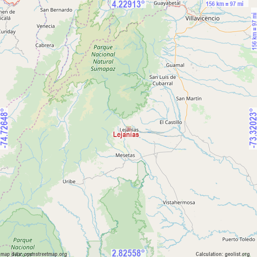
Lejanías GPS coordinates[2]
3° 31' 39.432" North, 74° 1' 24.06" West
| Map corner | latitude | longitude |
|---|---|---|
| Upper-left | 4.22913°, | -74.72648° |
| Center: | 3.52762°, | -74.02335° |
| Lower-right: | 2.82558°, | -73.32023° |
| Map W x H: | 156.1×156.1 km | = 97×97mi |
| max Lat: | 13.38166° ⇑81.5% North |
| Lejanías: | 3.52762° |
| min Lat: | ⇓18.5% South -4.21528° |
| min Long | Lejanías | max Long |
| -81.70636° | -74.02335° | -67.06996° |
| W 64.7%⇐ | ⇒35.3% E |
Elevation
Elevation of Lejanías is 689 m = 2260 ft, and this is 460.3 m = 1510 ft below average elevation for this country.
| Max E: |
3342 m = 10965 ft | 60.8% |
| Avg. | 1149.3 m = 3771 ft | |
| Lejanías | 689 m = 2260 ft | |
Min E: |
1 m = 3 ft | 39.2% |
See also: Colombia elevation on elevation.city.
Geographical zone
Lejanías is located in North Torrid zone (between Equator and Tropic of Cancer). Distance of Equator is 392.2 km =243.7 mi to South.| Distance of | km | miles | from Lejanías |
|---|---|---|---|
| North Pole | 9614.8 | 5974.4 | to North |
| Arctic Circle | 7008.9 | 4355.1 | to North |
| Tropic Cancer | 2213.7 | 1375.5 | to North |
| Equator | 392.2 | 243.7 | to South |


Nearby cities:
15 places around Lejanías: (largest is in red/bold)
• Acacías
59 km =36.7 mi,  29°
29°
• Cabrera
72.1 km =44.8 mi,  314°
314°
• Castilla La Nueva
49.9 km =31 mi,  48°
48°
• Cubarral
36 km =22.4 mi, 34°
• El Castillo
25.7 km =16 mi,  81°
81°
• El Dorado
31.5 km =19.6 mi,  41°
41°
• Fuente de Oro
45.2 km =28.1 mi,  99°
99°
• Granada
35.2 km =21.9 mi,  86°
86°
• Guamal
48.5 km =30.1 mi, 36°
• Mesetas
16.1 km =10 mi,  188°
188°
• Puerto Lleras
77.4 km =48.1 mi,  111°
111°
• San Juan de Arama
24.2 km =15 mi,  136°
136°
• San Martín
40.5 km =25.2 mi,  62°
62°
• Uribe
48.7 km =30.3 mi,  229°
229°
• Vistahermosa
54.1 km =33.6 mi,  146°
146°
Sources, notices
• [Note1] Compared only with cities in Colombia existing in our database
• [Src1] Map data: © OpenStreetMap contributors (CC-BY-SA)
• [Src2] Other city data from geonames.org with taken over terms of usage.
• [Src3] Geographical zone / Annual Mean Temperature by Robert A. Rohde @ Wikipedia
