San Juan de Arama geodata
San Juan de Arama (Meta) is a seat of a second-order administrative division; located in Colombia in America/Bogota (GMT-5) time zone. With population of 2,636 people, there are 724 cities with bigger population in this country. Compared to other cities in Colombia, 82.3% of cities are located further ↑North; 68% of cities are located further ←West and 65.2% of cities have higher elevation than San Juan de Arama. Note1


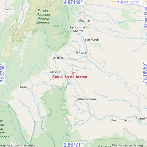
San Juan de Arama GPS coordinates[2]
3° 22' 11.46" North, 73° 52' 21.612" West
| Map corner | latitude | longitude |
|---|---|---|
| Upper-left | 4.07149°, | -74.5758° |
| Center: | 3.36985°, | -73.87267° |
| Lower-right: | 2.66771°, | -73.16955° |
| Map W x H: | 156.1×156.1 km | = 97×97mi |
| max Lat: | 13.38166° ⇑82.3% North |
| San Juan de Arama: | 3.36985° |
| min Lat: | ⇓17.7% South -4.21528° |
| min Long | San Juan de Ara | max Long |
| -81.70636° | -73.87267° | -67.06996° |
| W 68%⇐ | ⇒32% E |
Elevation
Elevation of San Juan de Arama is 438 m = 1437 ft, and this is 711.3 m = 2334 ft below average elevation for this country.
| Max E: |
3342 m = 10965 ft | 65.2% |
| Avg. | 1149.3 m = 3771 ft | |
| San Juan de Arama | 438 m = 1437 ft | |
Min E: |
1 m = 3 ft | 34.8% |
See also: Colombia elevation on elevation.city.
Geographical zone
San Juan de Arama is located in North Torrid zone (between Equator and Tropic of Cancer). Distance of Equator is 374.7 km =232.8 mi to South.| Distance of | km | miles | from San Juan de Arama |
|---|---|---|---|
| North Pole | 9632.4 | 5985.3 | to North |
| Arctic Circle | 7026.5 | 4366.1 | to North |
| Tropic Cancer | 2231.2 | 1386.4 | to North |
| Equator | 374.7 | 232.8 | to South |


Nearby cities:
15 places around San Juan de Arama: (largest is in red/bold)
• Acacías
69.8 km =43.4 mi,  10°
10°
• Castilla La Nueva
54.8 km =34.1 mi,  21°
21°
• Cubarral
47.4 km =29.5 mi,  4°
4°
• El Castillo
23.2 km =14.4 mi, 21°
• El Dorado
41.3 km =25.7 mi, 5°
• Fuente de Oro
29.7 km =18.5 mi,  69°
69°
• Granada
26.9 km =16.7 mi,  43°
43°
• Guamal
58 km =36 mi, 11°
• Lejanías
24.2 km =15 mi,  316°
316°
• Mesetas
19.1 km =11.9 mi,  274°
274°
• Puerto Lleras
56.3 km =35 mi,  101°
101°
• Puerto Lleras
64.8 km =40.3 mi,  126°
126°
• San Martín
41.1 km =25.5 mi,  27°
27°
• Uribe
55.4 km =34.4 mi,  255°
255°
• Vistahermosa
30.4 km =18.9 mi,  153°
153°
Sources, notices
• [Note1] Compared only with cities in Colombia existing in our database
• [Src1] Map data: © OpenStreetMap contributors (CC-BY-SA)
• [Src2] Other city data from geonames.org with taken over terms of usage.
• [Src3] Geographical zone / Annual Mean Temperature by Robert A. Rohde @ Wikipedia
